I am new to all this GIS work, so if I have done something silly or just plain wrong please just let me know.
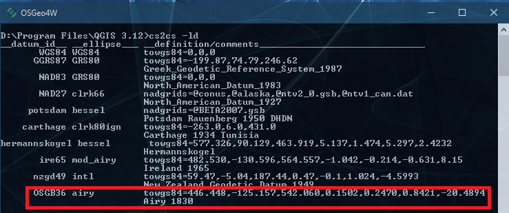
I m trying to covert from coordinates from OSGB 1936 / British National Grid to WGS84 but I am seeing different results to other tools.
My example coordinates X,Y is; 362895, 155602
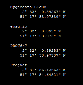
My conversions appear to be nearly correct however they are always a little out. Here is a link showing the conversion on epsg.io. If you switch the result to decimal you will see the expected results is;
Long=-2.5335813°, Lat = 51.2983258°
https://epsg.io/transform#s_srs=27700&t_srs=4326&x=362895.0000000&y=155602.0000000
I have also done the same conversion on https://mygeodata.cloud/cs2cs/ with the same results as epsg.io.
However in Proj.Net my result is;
-2.53225739401083, 51.2985133921956
Here is a code example to show my issues;
class Program
    {

        public const string wktOsgb1936 = "PROJCS[\"OSGB 1936 / British National Grid\"," +
        "GEOGCS[\"OSGB 1936\"," +
        "DATUM[\"OSGB_1936\"," +
        "SPHEROID[\"Airy 1830\",6377563.396,299.3249646,AUTHORITY[\"EPSG\",\"7001\"]]," +
        "AUTHORITY[\"EPSG\",\"6277\"]]," +
        "PRIMEM[\"Greenwich\",0,AUTHORITY[\"EPSG\",\"8901\"]]," +
        "UNIT[\"degree\",0.0174532925199433,AUTHORITY[\"EPSG\",\"9122\"]]," +
        "AUTHORITY[\"EPSG\",\"4277\"]]," +
        "UNIT[\"metre\",1,AUTHORITY[\"EPSG\",\"9001\"]]," +
        "PROJECTION[\"Transverse_Mercator\"]," +
        "PARAMETER[\"latitude_of_origin\",49]," +
        "PARAMETER[\"central_meridian\",-2]," +
        "PARAMETER[\"scale_factor\",0.9996012717]," +
        "PARAMETER[\"false_easting\",400000]," +
        "PARAMETER[\"false_northing\",-100000]," +
        "AUTHORITY[\"EPSG\",\"27700\"]," +
        "AXIS[\"Easting\",EAST]," +
        "AXIS[\"Northing\",NORTH]]";

        static void Main(string[] args)
        {
            // The orginal 27700 OSG co-ords
            var x = 362895;
            var y = 155602;

            var res = TransformSpatial(wktOsgb1936, x, y);

            // the long/lat which I am expecting as confirmed on other systems
            var shouldx = -2.5335813;
            var shouldy = 51.2983258;

            // A small calc to see the difference
            var difx = res[0] - shouldx;
            var dify = res[1] - shouldy;

            Console.WriteLine("From    : {0}, {1}", x, y);
            Console.WriteLine("conv    : {0}, {1}", res[0], res[1]);
            Console.WriteLine("Should  : {0}, {1}", shouldx, shouldy);
            Console.WriteLine("Diff    : {0}, {1}", difx, dify);

            Console.ReadLine();
        }

        public static double[] TransformSpatial(string wktFrom, double x, double y)
        {
            var cf = new CoordinateSystemFactory();
            var f = new CoordinateTransformationFactory();
            var sysFrom = cf.CreateFromWkt(wktFrom);
            var transformTo = f.CreateFromCoordinateSystems(sysFrom, ProjNet.CoordinateSystems.GeographicCoordinateSystem.WGS84);
            var ret = transformTo.MathTransform.Transform( x, y );
            return new double[] {
                ret.x, ret.y
            };
        }

    }
Please help and let me know what I am doing wrong, this is doing my head in!!
Is there a problem in my "From" mappings, my "To" mapping, is there another step I am missing or is there a bug?
Thanks in advance


