2

I'm trying to open and use a dataset (in the form of a shapefile) (https://webarchive.iiasa.ac.at/Research/FOR/forest_cdrom/data/landscapes/landscapes.zip) with QGis. The readme of the dataset says following about projection:

Projection: Lambert Azimuthal
Units: Meters
Datum: None
Parameters:
6370997.24063 (radius of the sphere of reference)
100 0 0.000 (longitude of center of projection)
45 0 0.000 (latitude of center of projection)
0.00000 (false easting (meters))
0.00000 (false northing (meters))

I tried to create a custom CRS with the following parameters:

+proj=laea +lat_0=45 +lon_0=100 +x_0=0 +y_0=0 +ellps=GRS80 +r=6370997.24063 +units=m +no_defs

With this custom CRS applied to the dataset it looks shifted along the basemap.

Am I wrong with the projection string? (I also tried to change ellipsoid to 'sphere', without visible improvements.)

2 Answers 2

4

The radius parameter must be +R instead of +r, but the +ellps takes precedence over +R, so in any case don't use +ellps because the information says that the projection is a conversion from the sphere.

The proj string must be:

+proj=laea +lat_0=45 +lon_0=100 +x_0=0 +y_0=0 +R=6370997.24063 +units=m +no_defs +type=crs

Also, take into account (from https://webarchive.iiasa.ac.at/Research/FOR/forest_cdrom/data/landscapes/readme.txt):

Data Limitations

Differences will occur between among the spatial datasets found here in terms of resolution and scale. In particular, the outer boundary of Russia, islands and waterbodies may vary between datasets. In addition, geo-registration is sometimes problematic with these datasets. As these datasets are derived from a variety of sources, it was not possible to control consistency.

2
  • 1
    I've read this note, but decided to check if my projection settings are right before attributing this shift to the dataset itself. The shift still exists after changing proj string to the one above, so I guess the issue is in the data limitations. (Hope it's possible to do something like raster georeferencing with a vector layer.)
    – Nick L
    Commented Jul 21, 2020 at 5:21
  • 1
    Yes, it is possible to do something like raster georeferencing with a vector layer. With ogr2ogr you can warp the layer with options -gcp and -order as with gdalwarp. With vectorbender plugin you can warp with linear triangles. Commented Jul 21, 2020 at 10:05
4

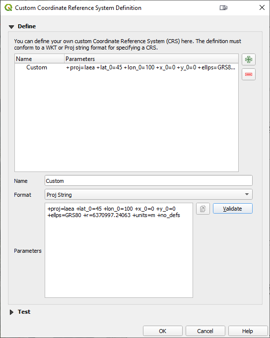
Your project parameters are valid, I just tried them. The problem is in some of the other *General projections-- they all need to be deleted until your CRS System Definition screen looks like this:

enter image description here

I arbitrarily named your custom CRS 'Custom'.

1
  • My CRS was the only custom CRS in QGIS at that moment. But I'll keep in mind this advice for the future, to use in case of interference of multiple custom CRS definitions, thanks!
    – Nick L
    Commented Jul 21, 2020 at 19:43

Your Answer

By clicking “Post Your Answer”, you agree to our terms of service and acknowledge you have read our privacy policy.

Not the answer you're looking for? Browse other questions tagged or ask your own question.