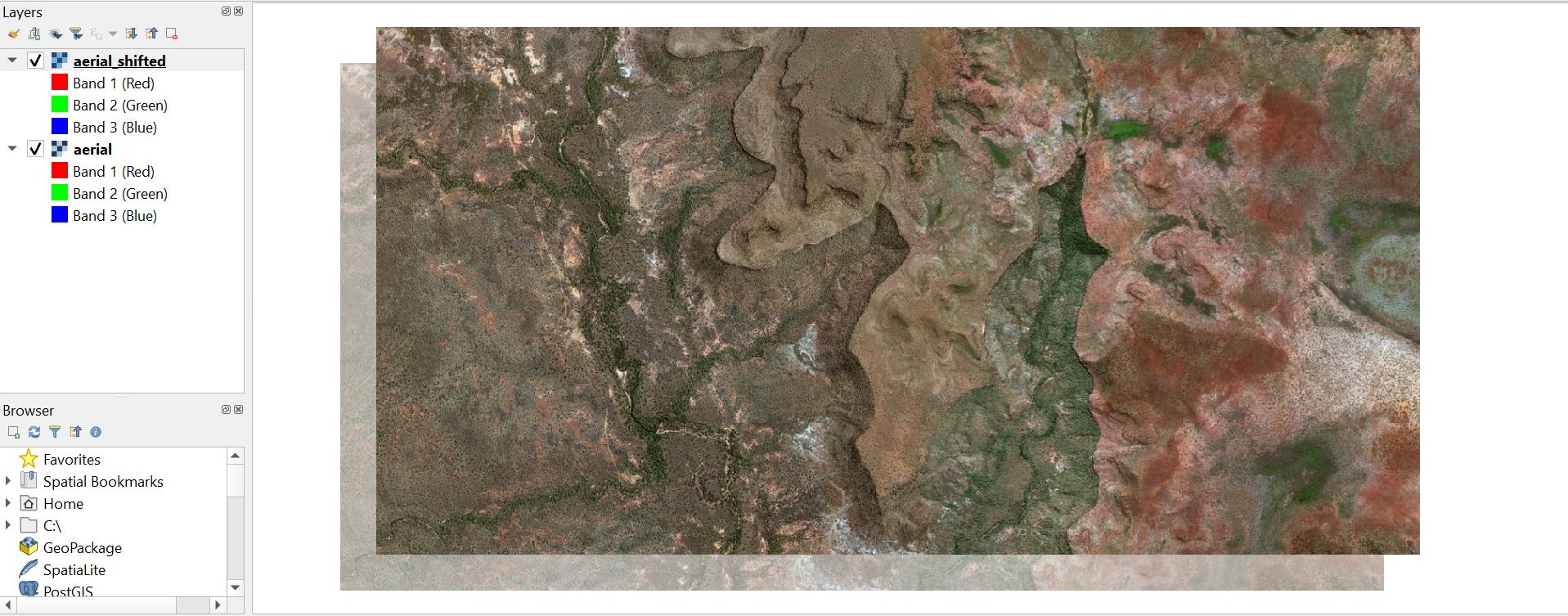
There may certainly be an easier/ better method, but you can try this script using the GDAL Python API, based on some of the examples found here.
You will need to edit first four executed lines after the import statement to define the paths to your input raster, path to where you want the output raster saved, then define your X and Y offset values (which may be positive of negative and are in the input raster CRS units).
You can run this script from an editor in the QGIS Python console.
if you have multiple rasters, all with the same required offsets, it would be easy enough to modify the script to loop over all .tif files in a directory.
from osgeo import gdal, osr

# Define input and output file paths
in_path = 'C:\\Path\\To\\Input_raster.tif'
out_path = 'C:\\Path\\To\\Output_raster.tif' # Will be created!

# Define desired X and Y offsets in input raster Spatial Reference System (SRS) units...
# ...using an accurate meter-based SRS e.g. an appropriate UTM CRS is strongly recommended
# Can be + or - values
x_offset = 250
y_offset = 250

raster = gdal.Open(in_path)

# Get input raster bands
input_bands = [raster.GetRasterBand(i+1) for i in range(raster.RasterCount)]

# Get input raster data type
data_type = input_bands[0].DataType

# Create list of bands read into arrays
band_arrays = [band.ReadAsArray() for band in input_bands]

geotransform = raster.GetGeoTransform()
originX = geotransform[0]
originY = geotransform[3]
pixelWidth = geotransform[1]
pixelHeight = geotransform[5]
cols = raster.RasterXSize
rows = raster.RasterYSize

driver = gdal.GetDriverByName('GTiff')
outRaster = driver.Create(out_path, cols, rows, len(input_bands), data_type)
outRaster.SetGeoTransform((originX+x_offset, pixelWidth, 0, originY+y_offset, 0, pixelHeight))

# Write array from each input band to each output band
for index, array in enumerate(band_arrays):
    outband = outRaster.GetRasterBand(index+1)
    if outband:
        outband.WriteArray(array)
        outband.FlushCache()

outRasterSRS = osr.SpatialReference()
outRasterSRS.ImportFromWkt(raster.GetProjectionRef())
outRaster.SetProjection(outRasterSRS.ExportToWkt())

outRaster = None
Result on a sample raster dataset:

Edit:
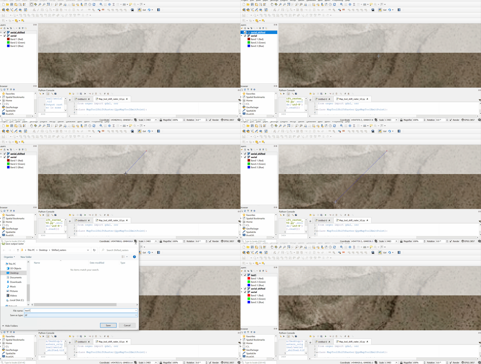
I have written a script using the QgsMapToolEmitPoint class which may improve your workflow if you can visually locate the same location/pixel on two slightly misaligned rasters. When you run this tool you can left-click on the raster you wish to move, then left-click again at the same location on your reference raster. The two points will be marked by QgsRubberBand point markers. You can re-click the two reference points until you are happy with them. Then right-click to finish. The two points will be used to calculate the X and Y offset values.
Paste the code below into an editor in the QGIS Python console. Select the layer you wish to move as the active layer, and click run.
Full script:
from osgeo import gdal, osr

class MapToolShiftRaster(QgsMapToolEmitPoint):

    def __init__(self, canvas, shift_layer):
        self.canvas = canvas
        self.shift_layer = shift_layer
        QgsMapToolEmitPoint.__init__(self, self.canvas)
        self.first_click = True
        self.pnt_A = None
        self.pnt_B = None
        self.X_offset = None
        self.Y_offset = None

        self.rb1 = None
        self.rb2 = None
        self.rb3 = None

    def canvasMoveEvent(self, e):
        if not self.first_click:
            if self.rb2:
                self.rb2.reset()
            geom = self.transform_geom(QgsGeometry().fromPolylineXY([self.pnt_A, self.toLayerCoordinates(self.shift_layer, e.mapPoint())]))
            self.rb2 = QgsRubberBand(self.canvas, QgsWkbTypes.LineGeometry)
            self.rb2.setToGeometry(geom)
            self.rb2.setColor(QColor('Blue'))
            self.rb2.show()

    def canvasReleaseEvent(self, e):
        if e.button() == Qt.LeftButton:
            if self.first_click:
                if self.rb1:
                    self.rb1.reset()
                if self.rb2:
                    self.rb2.reset()
                if self.rb3:
                    self.rb3.reset()
                self.pnt_A = self.toLayerCoordinates(self.shift_layer, e.mapPoint())
                geom = self.transform_geom(QgsGeometry().fromPointXY(self.pnt_A))
                self.rb1 = QgsRubberBand(self.canvas, QgsWkbTypes.PointGeometry)
                self.rb1.setToGeometry(geom)
                self.rb1.setIcon(QgsRubberBand.ICON_BOX)
                self.rb1.setColor(QColor('Red'))
                self.rb1.show()
                self.first_click = False
            elif not self.first_click:
                if self.rb2:
                    self.rb2.reset()
                self.pnt_B = self.toLayerCoordinates(self.shift_layer, e.mapPoint())
                if self.pnt_A and self.pnt_B:
                    geom = self.transform_geom(QgsGeometry().fromPointXY(self.pnt_B))
                    self.rb3 = QgsRubberBand(self.canvas, QgsWkbTypes.PointGeometry)
                    self.rb3.setToGeometry(geom)
                    self.rb3.setIcon(QgsRubberBand.ICON_BOX)
                    self.rb3.setColor(QColor('Red'))
                    self.rb3.show()
                    self.X_offset = self.pnt_B.x() - self.pnt_A.x()
                    self.Y_offset = self.pnt_B.y() - self.pnt_A.y()
                self.first_click = True
        elif e.button() == Qt.RightButton:
            if self.rb1:
                self.rb1.reset()
            if self.rb2:
                self.rb2.reset()
            if self.rb3:
                self.rb3.reset()
            self.shift_raster(self.shift_layer, self.X_offset, self.Y_offset)

#########################################################################

    def shift_raster(self, lyr, x_offset, y_offset):
        if x_offset is not None and y_offset is not None:
            in_path = lyr.source()
            print(in_path)
            out_string = QFileDialog.getSaveFileName(None, 'Save output raster', filter='.tif')
            file_name = out_string[0].split('/')[-1]
            out_path = ''.join(out_string)

            raster = gdal.Open(in_path)
            if not raster:
                print('Input raster is none')
                return

            # Get input raster bands
            input_bands = [raster.GetRasterBand(i+1) for i in range(raster.RasterCount)]

            # Get input raster data type
            data_type = input_bands[0].DataType

            # Create list of bands read into arrays
            band_arrays = [band.ReadAsArray() for band in input_bands]

            geotransform = raster.GetGeoTransform()
            originX = geotransform[0]
            originY = geotransform[3]
            pixelWidth = geotransform[1]
            pixelHeight = geotransform[5]
            cols = raster.RasterXSize
            rows = raster.RasterYSize

            driver = gdal.GetDriverByName('GTiff')
            outRaster = driver.Create(out_path, cols, rows, len(input_bands), data_type)
            if not outRaster:
                print('Output raster is none')
                return
            outRaster.SetGeoTransform((originX+x_offset, pixelWidth, 0, originY+y_offset, 0, pixelHeight))

            # Write array from each input band to each output band
            for index, array in enumerate(band_arrays):
                outband = outRaster.GetRasterBand(index+1)
                if outband:
                    outband.WriteArray(array)
                    outband.FlushCache()

            outRasterSRS = osr.SpatialReference()
            outRasterSRS.ImportFromWkt(raster.GetProjectionRef())
            outRaster.SetProjection(outRasterSRS.ExportToWkt())

            outRaster = None

            iface.addRasterLayer(out_path, file_name, 'gdal')

#########################################################################

    def transform_geom(self, geom):
        proj_crs = QgsProject.instance().crs()
        lyr_crs = self.shift_layer.crs()
        if proj_crs != lyr_crs:
            xform = QgsCoordinateTransform(lyr_crs, proj_crs, QgsProject.instance())
            geom.transform(xform)
            return geom
        return geom

    def deactivate(self):
        if self.rb1:
            self.rb1.reset()
            self.rb1 = None
        if self.rb2:
            self.rb2.reset()
            self.rb2 = None
        if self.rb3:
            self.rb3.reset()
            self.rb3 = None


layer = iface.activeLayer()
if layer.type() == QgsMapLayerType.RasterLayer:
    T = MapToolShiftRaster(iface.mapCanvas(), layer)
    iface.mapCanvas().setMapTool(T)
else:
    iface.messageBar().pushMessage('Please select a raster layer!')
See the screencast below for a short demo:

You can see the results after one run below. I was able to reduce the misalignment from over 250m to around 0.6m. If your rasters are only a few meters apart you should be able to align them almost perfectly in one go by zooming right in. Otherwise you should be able to achieve a satisfactory result on the 2nd go.


