4

I have an assignment that required us to convert projection using two different method. First method, convert directly from current coordinate system (Kertau_RSO_Malaya_Meters) into GDM 2000 Johor. The second method required us to convert the current coordinate system into Global (WGS84) first before converting into GDM 2000 Johor. The result that I get from both methods do not have any differences at all.

Can anyone explain what the differences is - if there is any - of using these two methods?

1
  • 2
    Since it's been answered I'll just add two comments to them. In any coordinate conversion there are alternate transformation methods that might produce very slightly different results or significant depending on your precision needs. This leads me to the second comment. When you say no differences I'd guess you are in effect saying they visually are the same at the scales you've used and/or they produce similar area/length or symbolized raster values, but if you look closely at vector coordinates or pixel values you might find differences.
    – John
    Commented Nov 28, 2022 at 13:14

4 Answers 4

7

In addition to the answer by @GeoMonkey as it might be a bit misleading: Reprojecting vector data can lead to differences. As for as the coordinates for the vertices are concerned, it is true that there is no difference if we ignore very tiny differences due to rounding errors and limitations in accuracy of the transformation used.

However, the lines connecting the vertices (in case you have line or polygon layers), these lines are drawn as straight lines in the projection used. So these lines differ for each projection. See this answer for such a case. The difference will be especially high for shapes with few vertices in large interval distance one from each other.

1
  • very good point for more complex geometries
    – GeoMonkey
    Commented Nov 28, 2022 at 23:31
6

Provided that you are using images, a resampling occurs each time the image is projected. This can alter the pixel values based on the resampling method used. The more times your reproject the more resampling is done.

If you are just reprojecting a list of coordinates then there is no difference.

5

To add to the answers of @GeoMonkey and @Babel and sum them up, there might be the following sources of additional error when using the two step transformation:

  • Two rounds of transformation always incur additional rounding errors and numerical inaccuracies because more calculations are performed, often involving complex functions whose values need to be approximated. However, in practice, this error is negligible most of the time - and if the following points do not apply, you might see no differences at all since they will be abstracted away by your GIS software's tolerance settings.

  • If the three coordinate systems differ in the underlying ellipsoid, there is (almost) always an approximative coordinate shift involved. It might very well be (I'm not familiar with the systems you mention) that your source and target system have a well-defined and accurate shift while the transformation used by your GIS software to and from WGS84 might be much rougher. Setting this up wrongly might incur errors up to a few dozen metres which is not negligible for most purposes; how to do it is dependent on the software you use.

  • If you choose to densify your vector lines before the transformation (ArcGIS "True Shapes" setting), there might be discrepancies when comparing the result to a dataset obtained using a different method, depending on how that one was obtained.

  • All of the above holds for vector data. For raster data (images), you want to avoid double transformations if at all possible since in addition to all of the above, the two rounds of resampling introduce much additional error; how much depends on the resolution of your raster.

2
  • Good point about underlying datums on which the projection systems are built!
    – GeoMonkey
    Commented Nov 28, 2022 at 23:32
  • Great, thanks a lot for this sum up!
    – Babel
    Commented Nov 28, 2022 at 23:44
0

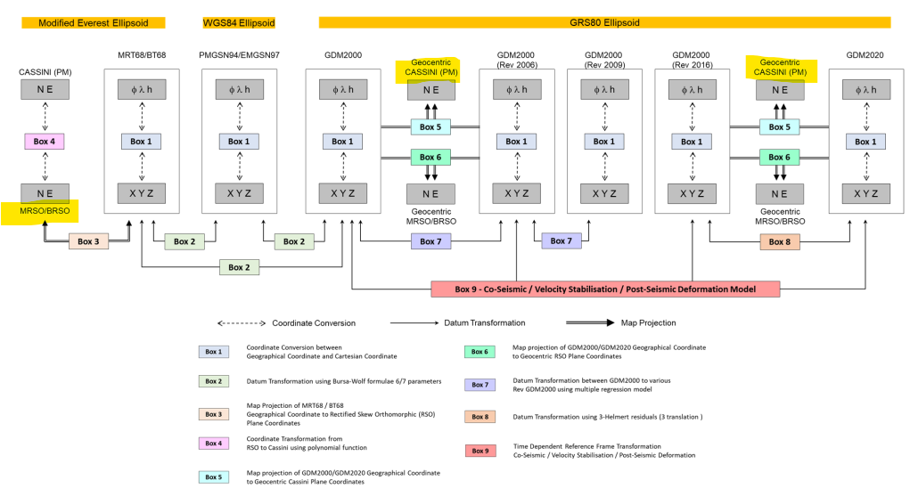
The diagram below is self-explaining.
enter image description here

The full document may be obtained here.

Since you mentioned Kertau RSO Malaya (in meter) and GDM2000 Johor in one breath/sentence, the diagram definitely applies.

Your source coordinates are most probably in the Malayan RSO (N, E) and in MRT68, highlighted in lower left corner. Note that Box 3 and Box 2 requires projection and datum transformation parameters not available publicly, and they must be obtained (via registration and fees) from the Department of Survey and Mapping Malaysia (JUPEM).

Your target coordinates, can be one or all of these:

  • N,E in Johor Cassini (in GDM2000), or
  • N,E in Johor Cassini (in GDM2000, Rev 2006), or
  • N,E in Johor Cassini (in GDM2000, Rev 2009), or
  • N,E in Johor Cassini (in GDM2000, Rev 2016), or
  • N,E in Johor Cassini (in GDM2000, Rev 2020).

You may not see any difference, or only very small differences when comparing the target coordinates in the various CRS because JUPEM took the approach of repositioning the Johor Cassini CRS origin in the various GDM2000 datum revisions. At a glance - the final Northings/Eastings may look the same, save for very minute differences, but in actual fact, they are in different (revised) datums, and they matters if and only if (1) you want to transform some GDM2000 coordinates from one GDM2000 revision to another GDM2000 revision, and (2) you want to transform the source coordinates to other global datums, e.g., WGS84 (G1762), WGS84 (G1674), ITRF2020, ITRF2014, and so on.

But again - mostly you can get away with (1) because the source and target Northings/Eastings will be the "same" or almost the same (within acceptable margin of errors) because JUPEM repositioned the CRS origin.

Your question only mentioned WGS84, hence I assume you meant the WGS84 ellipsoid and not any of the WGS84 datum. All GDM2000 datums are based on the GRS80 ellipsoid, which is very close to the WGS84 ellipsoid - mathematically, if you substitute the parameters (WGS84 for GRS80), you'd pretty much arrive at the "same" outputs.

Having said all the above - do note that JUPEM had never detailed how to transform any of the GDM2000 coordinates to any of the WGS84 or ITRF global datums. Reading the official document - you do have sufficient info to do so, but then they remain "unofficial", i.e., not fit for any legal or regulatory use.

Your Answer

By clicking “Post Your Answer”, you agree to our terms of service and acknowledge you have read our privacy policy.

Not the answer you're looking for? Browse other questions tagged or ask your own question.