0

I need a shapefile with polygon features. Each feature has to be a unique UTM zone (each zone is 6 degrees) in the northern hemisphere.

I have no idea how to make it - Create fishnet gives a wrong result, and making it by hand is a time consuming operation.

How to automate this, or maybe download shapefile somewhere?

5
  • Have you looked at these questions: gis.stackexchange.com/questions/7532/source-for-utm-zone-file Or gis.stackexchange.com/questions/26728/… Commented Jul 19, 2013 at 8:49
  • Thanks a lot !!! Have found this: baruch.cuny.edu/geoportal/data/esri/world/utmzone.zip
    – Vasiya
    Commented Jul 19, 2013 at 8:59
  • I am very surprised to hear that Create Fishnet is giving a wrong result - I find it to be one of the most common and reliable tools that I use.
    – PolyGeo
    Commented Jul 19, 2013 at 9:31
  • PolyGeo, as i understood, it gives parallel lines so when i need to make degree net it wont work (degree net is not parallel).
    – Vasiya
    Commented Jul 19, 2013 at 10:37
  • When you use a "geographic" coordinate system--its coordinates are in degrees of latitude and longitude--then indeed (most of) the UTM zone boundaries are regularly spaced. ("Parallel" is not a relevant concept here.) If you describe in more detail how you applied Create fishnet, perhaps someone will help you obtain the correct result with it.
    – whuber
    Commented Jul 19, 2013 at 13:14

1 Answer 1

1

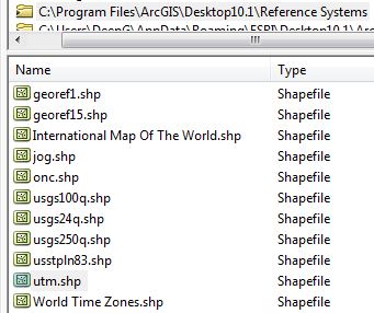
Your ArcGIS install should have a UTM Zones shapefile. Have a look under C:\Program Files\ArcGIS\Desktop10.1\Reference Systems

enter image description here

Your Answer

By clicking “Post Your Answer”, you agree to our terms of service and acknowledge you have read our privacy policy.

Not the answer you're looking for? Browse other questions tagged or ask your own question.