13

Can anyone suggest methods in filtering out trees and buildings from a DSM so as to come up with a reliable DEM?

What I have is a grid from a LIDAR data (.tif file, with 1m resolution). I was going to clean out the unnecessary items so I presume that I can solicit suggestions from here.

1
  • 3
    If you manage to get access to the gross LiDAR cloud, or if you are able to convert your Digital Surface Model back to a point cloud format, you can refer to this post to filter out non-ground returns and generate a bare-earth model (or DEM). Commented Aug 12, 2014 at 13:26

4 Answers 4

11

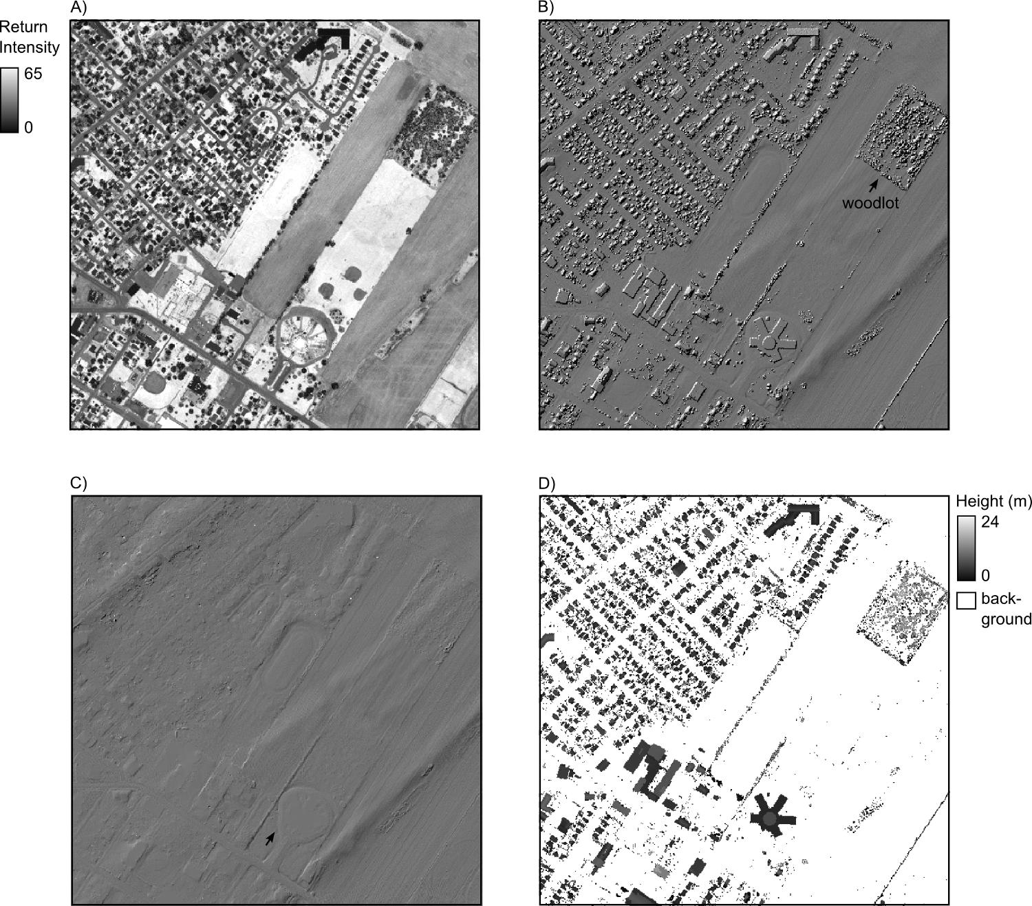
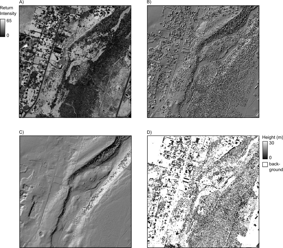
If you have a raster DEM already, then there is a tool that I developed in Whitebox Geospatial Analysis Tools called Remove Off-Terrain Objects, contained within the LiDAR toolbox, that works well for creating bare-earth DEMs, particularly in urban and agricultural settings. It works less well where either the terrain is steeply sloped or the forest cover is dense but it can still be useful under these settings. Compare part B (hillshade of original DEM) and part C (bare earth after processing with tool) in the figures below. Ultimately however @recurvata is correct in saying that the classification will be best if you can get the original source LiDAR data from which the grid was derived.

enter image description here

enter image description here

10
  • Thanks @whuber. It's hard to resist when there are such interesting questions ;) Commented Aug 8, 2014 at 19:45
  • hey @WhiteboxDev. . I've tried WhiteBox and it gives me error saying "An error has occurred during operation. See log files". . Actually, i don't know where to find the log files. .where could I find it? . .
    – vklopt
    Commented Aug 12, 2014 at 1:26
  • I did use it but it does not work fine and I've got an error during operation
    – vklopt
    Commented Aug 12, 2014 at 5:30
  • @vklopt send me an email and I'll see if I can figure out your problem. Commented Aug 12, 2014 at 11:16
  • @AndreSilva Andre, in essence the tool is cleaving steep-sided hills. You can see exactly how it works by pressing the 'View Code' button on the tool's dialog. Also, if you email me, I'll send you a work-in-progress manuscript describing the algorithm. Commented Aug 12, 2014 at 11:57
3

Also PCI has a tool for that DSM to DTM.Surface features such as buildings are mostly removed (minimized) by running a DSM2DTM, which searches for local minimum based on a user defined kernel (filter) size.

1
  • 1
    We are looking for longer answers that explain the solution in greater detail than 1 line.
    – Brad Nesom
    Commented Dec 23, 2014 at 14:20
2

I don't know what software you have, but if you have the lidar data you can filter on the classification. Ground is class 2. In ArcGIS, this is a good start.

3
  • hi. .actually, what i have is already a grid. . is it possible for it to be converted back to lidar point file to have the classification?
    – vklopt
    Commented Aug 4, 2014 at 1:01
  • I've only used lidar briefly, and that was a while ago. Is it possible the classification is in the grid's table? You might also want to post what software and version(s) you're using.
    – recurvata
    Commented Aug 4, 2014 at 14:52
  • i am also hoping that classification would be available on the grid's table, so i was thinking maybe when it could be classified when the grid is converted back to points. however, when i did this, the only attribute i can see is the elevations of the points. .so there could be no possibility that classification can be done with the grid. do you have any suggestions to clear out buildings/trees to have a bare earth elevation?
    – vklopt
    Commented Aug 8, 2014 at 0:46
0

This is a tutorial on how to remove vegetation from DEM https://learn.atlas.ugcs.com/docs/lesson-14-true-dsm-generation

Your Answer

By clicking “Post Your Answer”, you agree to our terms of service and acknowledge you have read our privacy policy.

Not the answer you're looking for? Browse other questions tagged or ask your own question.