5

How do you make the shapefile a Read-only so the client can not make any edits using 10.2.2 ArcGIS. It is not within a geodatabase, just a stand alone shapefile.

I am using Windows 8

2
  • 1
    You mean, besides just changing the file permissions?
    – Vince
    Commented Dec 18, 2014 at 16:28
  • You could also convert to a feature class in a FGDB and apply restrictions.
    – Aaron
    Commented Dec 18, 2014 at 20:22

2 Answers 2

6

As stated in GIS-Jonathan's answer this can be accomplished by setting the file permissions to Read-only.

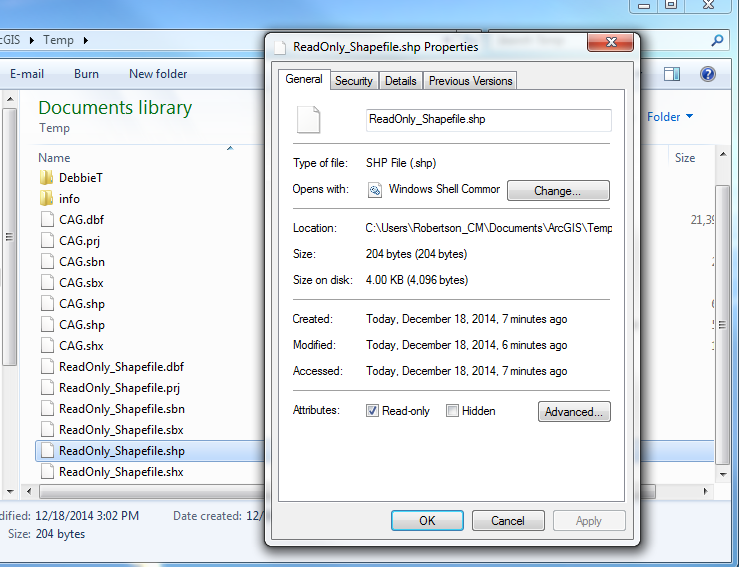
In windows 7 you can accomplish this by navigating to the file in windows explorer, right clicking the file with the .shp extension and clicking 'properties'. There should be two checkboxes near the bottom of the properties window that say 'Read-only' and 'Hidden', check the box that says 'Read-only'. As Vince notes in the comments it is probably best to repeat this step for the .shx and .dbf files. enter image description here
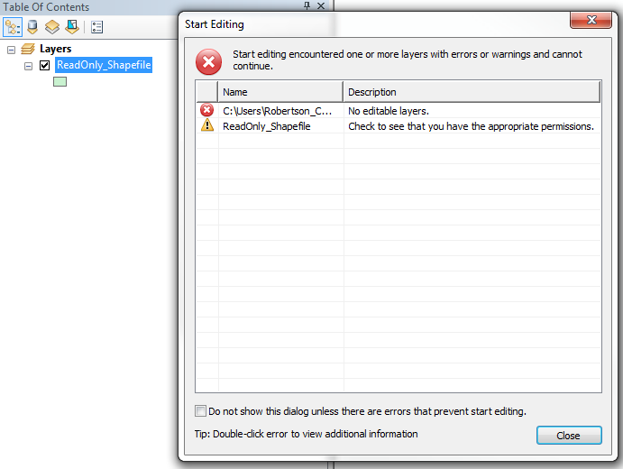
When loading the shapefile into ArcMap and attempting to edit the file the following error pops up: enter image description here
It is important to note however that the client can just change the file permissions back once they save the file to their PC so it wont really stop them from editing if they are aware of this.

2
  • 1
    It's probably wise to read-only the full triplet (.shp/.shx/.dbf), even if only one will suffice.
    – Vince
    Commented Dec 19, 2014 at 4:36
  • Updated answer, thanks @Vince and it makes that much more of a chore for the client to change them back. Commented Dec 19, 2014 at 13:45
-1

Strictly speaking this isn't really a GIS question because this is done outside of the GIS using the Operating System.

For that, try something like this: http://www.geekpolice.net/t4010-how-to-set-or-unset-the-read-only-folder-attribute-in-windows-7

5
  • Could you please add additional details so that this is not a link-only answer?
    – Aaron
    Commented Dec 18, 2014 at 16:36
  • @Aaron - given this is kind of out of scope for GIS anyway, I'm not sure that'd be useful here. Especially given we don't know which of the several possible operating systems Zoran is using. Commented Dec 18, 2014 at 16:38
  • To be fair to @Zoran this is only a non GIS question if you already know that it's not possible to lock a shapefile from within a GIS.
    – MAJ742
    Commented Dec 18, 2014 at 16:39
  • 1
    I disagree that this is out of scope since shapefiles are a spatial data format. If the OP was referring to non-spatial data formats like .gif, this would be a different story. More details on link-only answers available here: meta.stackexchange.com/questions/8231/…
    – Aaron
    Commented Dec 18, 2014 at 16:42
  • 2
    Also I am wondering since a 'shapefile' is generally composed of multiple files would you have to make all the associated files Read-only and if so that bit could also be added to the answer when editing. Commented Dec 18, 2014 at 19:11

Your Answer

By clicking “Post Your Answer”, you agree to our terms of service and acknowledge you have read our privacy policy.

Not the answer you're looking for? Browse other questions tagged or ask your own question.