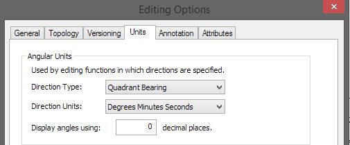
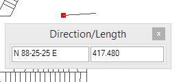
There are a couple of ways to go about it I think.
COGO is one way. It stands for "coordinate geometry" and is essentially a suite of tools designed specifically around digitizing parcels such as you're describing. Wha'ts nice is you can have a whole table put together of bearings and distances, which minimizes the possibility of error. Unfortunately, the COGO toolbar doesn't come with a Basic license. (Read over the Question I linked to, though, it mentions some alternatives to COGO which might be useful.)
HOWEVER, basic COGO methods are still available even with the basic license. When you are in an edit session, after you create a starting point, right-click and select "Direction/Length..." (or type Ctrl+G). This lets you input a bearing and distance for the next point. You can thereby make all your line segments according to the annexation ordinance.
(See This Question for some screenshots. I couldn't take one of my own machine.)
A good writeup of the process (including pictures) is in this GIS Obsessed Blog Post: COGO Made Easy in ArcGIS Desktop. I'm going to quote a couple of the most critical tips:
ArcMap will support several different types of units & you can enter unit types other than what you're using in your map by including a unit abbreviation after a distance. I've found some deeds that have distances in Rods, which are even supported in ArcMap (add rd after the distance).
So for S 00° 10' 24" W a distance of 962 feet -- if your map units are in meters, not feet (I had to do a lot of parcel work on a UTM map, reading from SC State Plane parcels in feet), your direction would be S 00-10-24 W and your distance would be 962ft.
If you're drawing a line in the opposite direction from the way that a plan shows it, just make sure that you flip the directions in your bearing, ie., if the plan shows the bearing as S 86-12-36 E and you are drawing the line the opposite way, just enter it as N 86-12-36 W.
This can be good for double-checking a deed, if you want to start at the "end" and work backwards and see if the parcel is correct.
The hardest part of this process is when you diligently follow through all the steps of the parcel outline per the survey description... and the end point doesn't meet up with the beginning point (and is hundreds of feet off). So you assume something went wrong, and you carefully go through again, and get back to the same discrepancy at the end. (When THAT happens, the survey is to blame and it's time to start making educated guesses about where the typo is in the writeup!) The advantage of COGO (or similar) is that you reduce the risk that you made a typo somewhere in the editing process.


