2

Is there a service that can provide custom tiles in the EPSG:4326 projection? I've looked at Cloudmade and it would be the ideal solution but their tiles are using Spherical Mercator.

Basically the end result I'm looking for is to create a square grid overlay on a map. Like this : http://openlayers.org/dev/examples/graticule.html

So retrieving the maps via WMS would be a good choice but I need the map to be custom styled like you would be able to do in cloudmade. But maps like cloudmade and google maps seem to distort the world and so a square grid won't be possible on their tiles if i wanted to create the grid by equal increments of latitude and longitude.

4
  • 2
    So you're looking for rendered tiles of OpenStreetMap in WGS84?
    – underdark
    Commented Sep 2, 2011 at 11:03
  • Yes I think thats the case underdark. Please see my comment below to see what I'd like to do
    – hank
    Commented Sep 5, 2011 at 9:12
  • Just wondering if anyone has any more info to add on this? Thanks all
    – hank
    Commented Sep 7, 2011 at 13:42
  • Thanks underdark, could you please share some info on achieving a square grid in Web Mercator?
    – hank
    Commented Sep 7, 2011 at 18:44

4 Answers 4

2

ESRI previously published base maps with their ArcGIS Online Tiling Scheme, which is in WGS 1984 geographic coordinate system / EPSG:4326 - for example this ESRI Street Map. You can search their online map services here for more examples.

Unfortunately they seem to be phasing these out and going with the Web Mercator / Google tiling scheme from now on. This is a real shame, as I think there is a huge demand for a geographic projection, and ESRI have missed a chance to differentiate themselves from Google and Microsoft and cater for a more GIS orientated developer base:

ArcGIS Online maps published and hosted by Esri have been migrated to the Google Maps/Bing Maps tiling scheme. Esri will continue to host the existing ArcGIS Online maps (e.g., World Street Map, World Imagery, and so on) in the traditional ArcGIS Online tiling scheme for at least six months and, depending on demand, they may remain available longer in order to give users ample time to migrate their maps and applications to the new services. Although the maps will remain available, the content in these maps will no longer be updated.

Source

So once these services are taken offline it looks like you have to roll your own, work with Mercator, or hope someone will provide a similar service before ESRI's services are shutdown.

5
  • 1
    Ah, unfortunetely due to the nature of the project we can't risk going with those maps incase they decide to take them down. But thanks anyways (: And yes it is a shame. Especially since all the leading web map services are giving people a false idea of the proportions of the world
    – hank
    Commented Sep 7, 2011 at 20:27
  • 2
    WGS84 doesn't solve that problem though.
    – underdark
    Commented Sep 8, 2011 at 16:07
  • @underdark - which problem? Commented Sep 8, 2011 at 16:15
  • " false idea of the proportions of the world"
    – underdark
    Commented Sep 8, 2011 at 16:32
  • @underdark you mentioned a square grid is possible in Web Mercator. Could you please share some info one how that can be achieved or any links?
    – hank
    Commented Sep 8, 2011 at 21:05
1

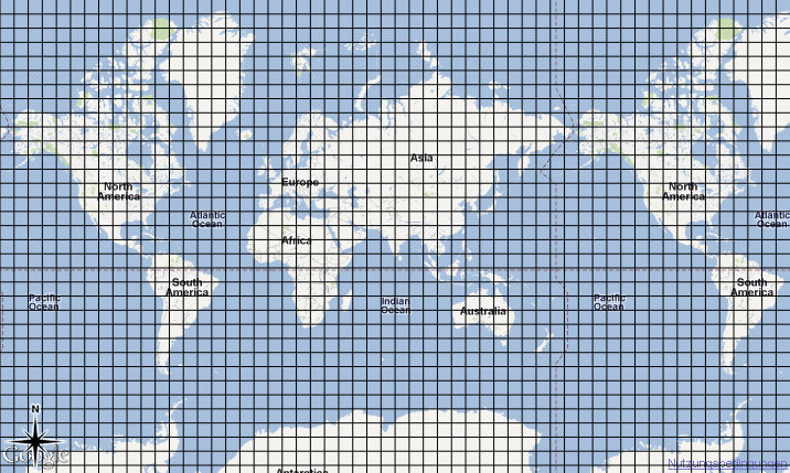
You can create a square grid on Web Mercator too. I did the following example in QGIS using "Vector grid" with grid size = 1,000,000 meters.

enter image description here

Neither Web Mercator nor WGS84 preserve real length measurements, so if you're just after a square grid I don't see much difference.

1
  • Thanks underdark. I was able to replicate what you did using gqis but I think a solution like this would require me to import KML files into google maps/cloud made and because I require these grids at every zoom level so file size and performance is going to be an issue. Im looking at a way of drawing these grids within google maps. Can you suggest such a solution that would produce the same output as the map you generated above?
    – hank
    Commented Sep 16, 2011 at 13:23
1

Have you tried metacarta?

http://labs.metacarta.com/wms-c/Basic.py/1.0.0/basic/{z}/{x}/{y}.png"

or like this:

http://tilecache.osgeo.org/wms-c/tilecache.py/1.0.0/basic/5/32/23.png

Both are EPSG 4326. No, they are not full styling services like CloudMade, but they do give you slippy tiles, and the creating the grid is up to you as a layer over that. Did I miss something?

0

Openlayers

SphericalMercator and EPSG aliases

The SphericalMercator projection in OpenLayers uses code EPSG:900913. Many other services, such as OpenStreetMap, Bing and Yahoo are now also using the same projection, but are not necessarily supporting the use of code EPSG:900913. Other codes, such as EPSG:3857 and EPSG:102113 were invented. Today, there is an officially registered EPSG code 3857 whose projection is identical to EPSG:900913. (http://www.epsg-registry.org/export.htm?gml=urn:ogc:def:crs:EPSG::3857). So, if you need to combine overlay layers that are using either an alias or the official EPSG code with an OpenLayers SphericalMercator layer, you have to make sure that OpenLayers requests EPSG:3857 or other alias in stead of EPSG:900913. You can accomplish this by overriding the layer projection before adding the layer to the map. For example:

// create sphericalmercator layers
var googleLayer = new OpenLayers.Layer.Google("Google", {"sphericalMercator": true});
var osmLayer = new OpenLayers.Layer.OSM("OpenStreetMap");

// override default epsg code
aliasproj = new OpenLayers.Projection("EPSG:3857");
googleLayer.projection = osmLayer.projection = aliasproj;


//add baselayers to map
map.addLayers([googleLayer, osmLayer]);

At this point, overlays (such as WMS layers) will be requested using the 3857 code; transformations will work between 4326 and 3857 as expected.

http://docs.openlayers.org/library/spherical_mercator.html

1
  • Thanks for the reply Mapperz Sorry I'm really new to this and so I think I may have asked the question incorrectly. If I can try rephrase it. Basically the end result I'm looking for is to create a square grid overlay on a map. Like this : openlayers.org/dev/examples/graticule.html So retrieving the maps via WMS would be a good choice but I need the map to be custom styled like you would be able to do in cloudmade. But maps like cloudmade and google maps seem to distort the world and so a square grid won't be possible on their tiles if i wanted to create the grid by equal increments of
    – user4120
    Commented Sep 2, 2011 at 21:09

Your Answer

By clicking “Post Your Answer”, you agree to our terms of service and acknowledge you have read our privacy policy.

Not the answer you're looking for? Browse other questions tagged or ask your own question.