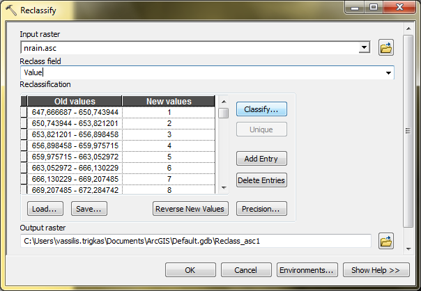
Is there a way to perform a reclassify of a raster image in QGIS?
In ArcGIS Desktop you can do that in Spatial analyst Tools→Reclass→Reclassify

I was able to reclassify a raster using the raster calculator
Here the "Habitat" raster is reclassed from continuous values (0-1) to discrete values of 1,2,3
("Habitat@1" < 0.3)* 1 + (("Habitat@1" >= 0.3) AND ("Habitat@1" < 0.6)) *2 + ("Habitat@1" >=0.6)* 3
Using GRASS and the r.reclass module, yes. However, you actually need to use the keyword "thru".
Example: For a raster elevation grid, to be reclassified into values based on 100m-intervals:
500 thru 599.99 = 500
600 thru 699.99 = 600
700 thru 799.99 = 700
Etc.. And you save that into a notepad text document(with no spaces between lines). Then when opening the r.reclass module, you will simply load that rulefile into the gui and away you go.
Experience: I just performed a reclassification on a DEM for my thesis project in Tajikistan over the weekend using this method and it worked a treat.
*Note(caveat): You might look into modeling this process or even using GDAL to output a *.prj file alongside the output for use in Arc, as the outputs I've seen from this thus far contain no projection definition readable by Arc. If you're sticking with QGIS, tho, then you should be good-to-go.
One more thing, as with any QGIS/GRASS/GDAL processes, ensure you have downloaded the OSGeo4W Installer which ensures you have everything up-to-date: http://trac.osgeo.org/osgeo4w/
QGIS now has two native raster reclassify algorithms
Reclassify by layer - allows you to use a vector layer to dictate your ranges
Reclassify by table - works much like ArcGIS raster reclassify spatial analyst tool.
These were added in QGIS 3.2 see the change log here.
With the Advanced Interface option of the toolbox, I use the Reclassify Grid Values from the SAGA GIS, It a really intuitive tool with options of reclassification by single value, range and using a table.
I prefer this over the r.reclass because you do not have to create additional files.
The easier way is to use GRASS (also using the QGIS/GRASS plugin) and the r.reclass module.
You will need to create a reclassification rule file, where you can use the keyword "through" or the wildcard "*" to reclassify multiple values in one rule.
I guess my post doesn´t aswer the question accurately, but it could maybe provide some help. I haven´t found a simple way to do this in QGIS, like Bryce I use GRASS modules. However, if have ArcGIS but no Spatial Analyst, there´s another great tool: GME (http://www.spatialecology.com/gme/). It´s dependent on ArcGIS and R and has a multitude of really great features, one of them beeing 'reclassify'. Here, just like in GRASS, you need to create a text file containing the class definitions. I´ve used ArcMap to visualize the raster in question in different ways first to get a better idea of what the data looks like. Then I´ve defined the new classes based on that info. Its worked like a charm for me. I don´t know if GME will run on a system without ArcGIS, I´d be curious to know.