3

I am working on a change detection study to look at effects of herbicides on vegetation growth. Therefore I have Worldview 2 (4 band +pan band) imagery for two subsequent years that I would like to use for a change detection analysis, but need some advice on appropriate pre-processing steps.

My proposed techniques to evaluate the change is first is a simple comparison of NDVI between the two years and secondly to run a Random Forest Classification in R. I have been trying to follow the guidance outlined in the Digital Globe Radiometric Use of Worldview 2 Imagery document, but am having a bit of trouble deciphering exactly what formulas I need to use to make my imagery comparable between years.

Initially, my workflow was to:

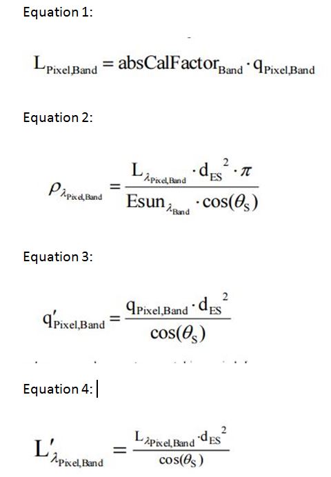
1) Convert to DN to Top-of-Atmosphere Spectral Radiance using the second formula from section 5.1 of the document (see equation 1 below) using ArcGIS raster calculator.

2) Convert results from step 1 to Top of Atmosphere band-average reflectance using the last equation from section 7 of the technical document (see equation 2 below) using ArcGIS raster calculator.

3) Run the NDVI and R forest classification using the appropriate Top of Atmosphere band-average reflectance layers.

However, after re-reviewing the Digital Globe technical document, I am wondering if I also need to complete the radiometric balancing for multiple scenes outlined in Section 6 (See equations 3 or 4 below) or is step already accounted for in the formula for converting to Top of Atmosphere band-average reflectance (Equation 2)?

Equations From Technical Document Proposed:

enter link description here

5
  • Welcome to GIS SE! Thank you for taking the tour, and I hope you will follow on from that by investigating the help center too. As it stands I think your question is too broad for two main reasons: 1. it is effectively asking the same question twice, once for each of ArcGIS and QGIS; and 2. it seems to be seeking a project review rather than asking a single focussed question about something that you have tried and become stuck on.
    – PolyGeo
    Commented Jan 31, 2016 at 23:08
  • Ok. Simplified to one question and removed reference to QGIS, although not sure that was necessary as the question is more procedural rather than software specific. I guess its sort of a project review, but thats what my question is about. Whether I'm calculating the TOA properly to compare images or if further radiometric processing is required. It is not clear to me from the Digital Globe technical document which steps are necessary so thats what I'm trying to clarify first.
    – user66281
    Commented Feb 1, 2016 at 0:22
  • I'll re-open because you are new here but be aware that this is a Q&A site, and not a discussion forum, so project reviews are too broad. Asking a specific question about something that have tried and become stuck on is a way that can help you to perform *your" own project review.
    – PolyGeo
    Commented Feb 1, 2016 at 0:32
  • Ok. Thank you . Are you aware of any other sites, that would be more open to discussions on project reviews? Most textbooks and websites I find are so broad with respect to remote sensing methodology its often difficult to know the current best practices for certain methodologies and hence the reason I'm looking for advice from those with more expertise than myself.
    – user66281
    Commented Feb 1, 2016 at 1:57
  • There may be LinkedIn groups for that
    – PolyGeo
    Commented Feb 1, 2016 at 2:30

1 Answer 1

1

Subtracting the pixel value from the actual or expected value of the dark object is the idea. I will advice that you do that on the natural DN before converting to TOA reflectance. And since you are using QGIS for the analysis, I will suggest that you use the "Semi Auto Classification Plugin" to do the raster processing.

Your Answer

By clicking “Post Your Answer”, you agree to our terms of service and acknowledge you have read our privacy policy.

Not the answer you're looking for? Browse other questions tagged or ask your own question.