1

I've done quite a bit of research here and elsewhere and am still having trouble coming up with a solution for measuring volumes using a DEM derived from high-resolution (1 m) stereo satellite imagery.

The closest solution I have found so far has been this: "How to calculate the volume of several DEMs to obtain elevation and volume changes?".

I understand that the 3D analyst extension within ArcGIS would be able to accomplish this, however, I am limited to the availability of open source software such as QGIS which I am an active user of.

2
  • 3
    A first approximation is just the sum of the DEM values multiplied by the area of a DEM pixel, when you use the same units for each. That should be doable in the QGIS expression calculator...
    – Spacedman
    Commented May 5, 2016 at 21:52
  • look at How much rock was erupted from Mt St Helens? in Python only
    – gene
    Commented May 6, 2016 at 8:27

1 Answer 1

3

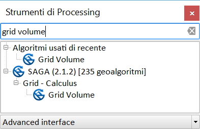
QGIS can use the GRASS GIS and SAGA GIS tools that solve the problem (example uses GRID VOLUME by SAGA GIS from processing). enter image description here

2
  • pigreco, i can't find those tools in the SAGA
    – newGIS
    Commented Aug 7, 2017 at 7:08
  • Raster volume searches - they probably changed the name
    – pigreco
    Commented Aug 8, 2017 at 7:54

Your Answer

By clicking “Post Your Answer”, you agree to our terms of service and acknowledge you have read our privacy policy.

Not the answer you're looking for? Browse other questions tagged or ask your own question.