I am trying to georeference sovet military maps from maps.vlasenko.net. I have manage with one, but to my surprise I am failing badly with georeferencing a second file (M33-3 map). Let me go piece by piece.
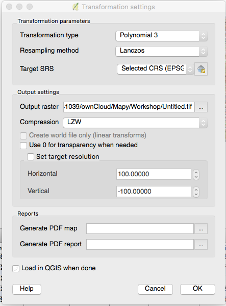
I am using georeferencer plugin of QGIS. I have defined about 20 ground control points, and below I paste my settings: [image file below]
Now the problem when "targer resolution" tickbox is checked I am getting "failed to compute GCP transform: transform is not solvable". I am surprised to find that the parameters describing the resolution of the output file should determine whether the GCP problem can be solved on not.
When I set the resolution to 1 -1 i get an output file which is (2x3 pixels - TWO by THREE pixels, six in total, any other resolution results in the above error).
Additionally:
why the vertical resolution is negative? Setting it to a positive value is not possible (program does not accept any string which does not start with a minus sign)
edit: now, due to comments, I know that the resolution referes to "distance" between the two pixels in the real world but what is the exact definition? distance in "degrees" between two pixels meaning if I set resolution to -0.001 I will get 1000 points between 48N and 47N?The output file if it is generated is 4416x2868, while the inupt file was 3640x3690. How do I prevent QGis from redusing the vertical resolution?
These are my points:
mapX,mapY,pixelX,pixelY,enable
12.5,49.6666666666666643,696.44124605543004236,-679.36131645390867106,1
13,49.6666666666666643,1258.51471519414258182,-684.41549413144286973,1
13,49.3333333333333357,1256.54119318181801646,-1269.91464359504129789,1
13,48.6666666666666643,1248.05952995867664868,-2436.66748450413160754,1
14.5,49.3333333333333357,2953.55126647356382819,-1261.53862463428208684,1
14.5,48.6666666666666643,2969.13251018327309794,-2429.89975814664012432,1
15,48,3564.46622379741438635,-3586.28640693407032813,1
12,48,76.4774047927286631,-3589.3263771639708466,1
12,50,145.94363378099018291,-86.07935175619095958,1
15,50,3494.49134769610191142,-85.47891450564263494,1
12,49,111.34988378099140505,-1837.0186596074308909,1
15,49,3530.48463326446426436,-1836.4230371900771388,1
13.5,48,1821.41237949674950869,-3604.3516086135855403,1
13.5,50,1820.503563331398027,-101.45661704556296456,1
13.5,49,1821.47190893987476557,-1852.47153220938480445,1
14,49.6666666666666643,2382.41388305881719134,-683.36089241037620923,1
12.5,48.3333333333333357,667.39443784955994943,-3013.91477973141627444,1
14,48.3333333333333357,2399.19324876641030642,-3018.47076644672188195,1
14.5,48.3333333333333357,2976.20023527521971118,-3012.75593990486959228,1
14,49.3333333333333357,2387.19608165803492739,-1267.08280010578459951,1
14.5,49.6666666666666643,2945.54654068545914924,-678.16992496819614189,1
14.5,50,2937.55372078595246421,-94.48770356814071647,1

