1

I have a TIF Image in EPSG:31467 and need to reproject it to EPSG:25832 and convert to ECW format. I have to do this with FME2017 as ESRI does not write to ECW without the ECW licence. After transforming, I then load the image into ArcGIS 10.3.1 and see that the resulting image gets the coordinatensystem EPSG: 2632 (NUTM32) assigned to it. Where does this NUTM32 System come from? If I do the same with a SHP from 31467 to 25832 it works fine and shows the right coordinatsystem in ArcGIS.

Why does this work differently for images?

2
  • Note: if the raster's not huge, drop me an email to arrange how to get it and I can try it in a later version. mkennedy at esri
    – mkennedy
    Commented Mar 28, 2017 at 17:43
  • This seems very similar issue knowledge.safe.com/questions/29791/…
    – user30184
    Commented Mar 28, 2017 at 20:31

2 Answers 2

2

Many formats have their own names and definitions for coordinate systems; ECW and Shape seem to allow different coordinate systems under different names - hence the difference between the two.

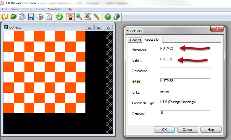
I don't see anything that suggests EPSG numbers are stored inside ECW datasets. Instead UTM projections are stored like NUTM32 (Northern hemisphere, UTM zone 32).

Similarly, the datum for that projection is usually EPSG:6258, but instead FME will write it as ETRS89, because that's what is expected in an ECW dataset.

I just tried creating an ECW file in EPSG:25832 and viewing it in ER Viewer and that is exactly what I see:
enter image description here

I do have some suggestions...

  1. Make sure you're using FME2013 build 13089 or greater (I would hope so!) as there was a fault writing that coordinate system to ECW before that point
  2. Can you try viewing the data in ER Viewer as I did, to ensure the results are correct there? I do notice there is an EPSG field there. Why it is not filled in with an EPSG number I do not know.
  3. I've no idea where ArcGIS gets EPSG:2632 from. It doesn't seem to be related at all. The key thing is to avoid having the data reprojected unnecessarily when it is opened. If you suspect that might be happening, let us - or Esri - know about it.
1

Imagery in ArcGIS uses a different pathway than vector data when handling the coordinate reference systems. Both data types use the projection engine, but imagery also uses an Esri-adapted version of GDAL, which uses PROJ4.

GeoTIFFs, in particular, have their own, quite old, standard which is based on the EPSG registry.

In the end, the raster/image side can get out-of-sync with the Esri projection engine and its current version of the EPSG registry.

Your Answer

By clicking “Post Your Answer”, you agree to our terms of service and acknowledge you have read our privacy policy.

Not the answer you're looking for? Browse other questions tagged or ask your own question.