37

UTM zones 30V, 31V, 32V, 31X, 33X, 35X, and 37X do not line up with the rest of the UTM zone grid.
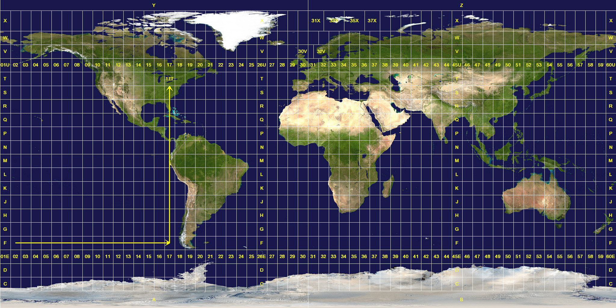
UTM zone map

Why was this allowed? According to Wikipedia, UTM was developed by the U.S. Army Corps of Engineers in the 1940s. What prompted them to have special zones for Norway and not for any other country?

3
  • This is a wild guess based on almost no actual facts, but it's been so long since I've even been able to guess at answers here: Submarines. The Germans had tons of U-boats based in Norway during the Second World War. Commented Oct 14, 2010 at 0:54
  • I don't blame you for guessing - I can't see a reason why UTM zones are so crazy in Norway. The rationale for extending the zones for convenience could have been applied in many other places.
    – Jaime Soto
    Commented Oct 14, 2010 at 2:30
  • 3
    Note that the physical width of the strip where a UTM zone maintains acceptable accuracy is constant. Towards the north and south, the strip covers ever wider ranges of longitude until, near the poles, any of the 60 UTM zones would be fine! Accordingly, there is a lot of flexibility to broaden the east-west ranges (in terms of longitude) of the zones used in extreme latitudes. That flexibility was not exercised in Antarctica (I wonder why ;-) but was used somewhat opportunistically to adapt some of the northern zones to political divisions, as explained in the replies.
    – whuber
    Commented Mar 24, 2011 at 21:03

4 Answers 4

18

The closest I've found to an answer is in the DMA technical manual 8358.1, which states:

3-2.2.1 For that portion of the world where the UTM grid is specified (80° south to 84° north), the UTM grid zone number is the first element of a Military Grid reference. This number sets the zone longitude limits. Zone 32 has been widened to 9° (at the expense of zone 31) between latitudes 56° and 64° to accommodate southwest Norway. Similarly, between 72° and 84°, zones 33 and 35 have been widened to 12° to accommodate Svalbard. To compensate for these 12° wide zones, zones 31 and 37 are widened to 9° and zones 32, 34, and 36 are eliminated.

2
  • I thought it had something to do with Svalbard. Nice. Commented Oct 14, 2010 at 1:19
  • 2
    It's odd that they did not use that rationale for other parts of the globe. For example, this rationale could have also be applied to extend the longitude span of some of the zones that cover the Hawaiian islands, Iceland, or Great Britain.
    – Jaime Soto
    Commented Oct 14, 2010 at 1:28
12

I emailed USGS and got this response:

zone 32 is 9 degrees wide in zone designator V is 9 degrees wide for the purpose of including the west coast of Norway within a single zone. Zones 33 and 35 are 12 degrees wide in zone designator X for the purpose of putting Svalbard into two zones instead of three. In both examples, the UTM system was modified for the purpose of convenience.

5

I found an article[1] about the history of grids and datums in Norway. I do not understand many of the details in the article, but it seems like 32V was extended for compatibility with previous grids. The article does not offer a clear explanation about Svalbard.

[1]: Mugnier, C. I. Grids and Datums: The Kingdom of Norway. Photogrammetric Engineering and Remote Sensing. American Society for Photogrammetry and Remote Sensing (ASPRS), October 1999. pp. 1129-1132. Accessed online on 20 August 2011. http://www.asprs.org/a/resources/grids/10-99-norway.pdf.

1

According to the major Norwegian encyclopedia the special boundaries for 32V were established by American Army engineers hunting for German subs by the west coast of Norway in the early 1940s. The article references the same article by Mugnier as https://gis.stackexchange.com/users/986/jaime-soto references. No explanation is offered for the Svalbard zones.

Your Answer

By clicking “Post Your Answer”, you agree to our terms of service and acknowledge you have read our privacy policy.

Not the answer you're looking for? Browse other questions tagged or ask your own question.