2

I have composed a map where shapefiles, points etc. all are in local coordinate system (l-est).

Is it possible to convert it to common WGS84 system?

So that in printed map there are coordinates 23.906250;59.432234 (not local 6506050; 4534232)?

I've tried to change it under items properties -> the CRS selector, but no luck.

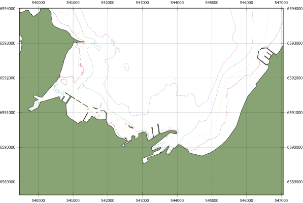
At the moment in "QGIS print composer" I have this picture:

enter image description here

4
  • 1
    Welcome to GIS.SE. An example image of how you currently incorporate the coordinates in your layout would be helpful in order to answer the question.
    – Erik
    Commented Apr 25, 2019 at 13:14
  • Sorry, here is the picture. i.ibb.co/sFHBFrF/Untitled2.png
    – fred
    Commented Apr 25, 2019 at 13:48
  • Feel free to edit your post so it contains the image ;-)
    – Erik
    Commented Apr 25, 2019 at 13:53
  • PolyGeo just deleted my picture from the original post.
    – fred
    Commented Apr 25, 2019 at 13:56

1 Answer 1

4
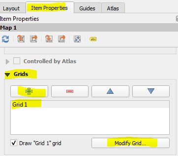
  1. In Printcomposer go to Item Properties and scroll down to Grids
  2. Modify your existing grid or create a new one and modify this one

enter image description here

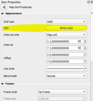
  1. At the top (in appearance) you can change the coordinate system of your grid:

enter image description here

Choose a fitting Interval.

In case you want to to change the projection of your map, you need to do this in your main project:

enter image description here

0

Your Answer

By clicking “Post Your Answer”, you agree to our terms of service and acknowledge you have read our privacy policy.

Not the answer you're looking for? Browse other questions tagged or ask your own question.