2

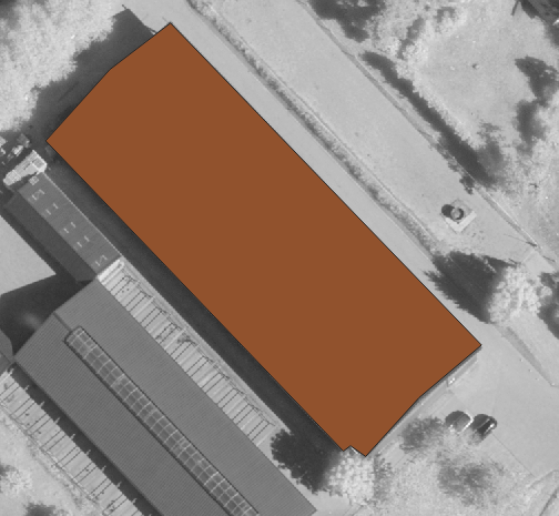
Sometimes I get polygon data that digitizes buildings, but they are slightly displaced like in the following example

enter image description here

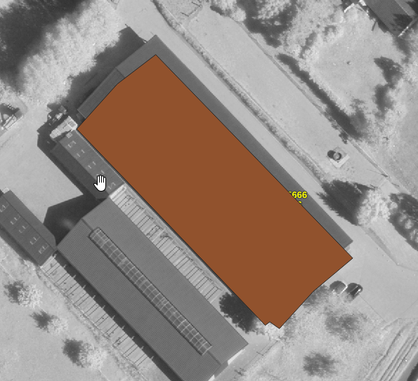
However, when I use the ArcGIS Tool "Project" to project the layer from a geographic to a projected CRS the displacement is corrected.

enter image description here

I have tried to do the same with the QGIS Tool "reproject Layer" but it doesn't work. The tool does change the unit of the extent from degrees to meters but it has no effect on the representation.

Honestly, I don't really know what is happening in the ArcGIS tool. In the description it says that "project" changes the unit from degrees to meters, thus it does the same as QGIS "reproject" but the results are not the same. Does anyone know what is happening here and can explain it to me?

EDIT

Actually, I made a mistake. I wasn't projecting from unprojected to projected but from a DHDN based to a ETRS_1989 based projection

5
  • 8
    Please Edit the question to specify the source and destination coordinate references, as well as the exact parameters you used in both reprojection attempts. This is likely a datum transformation issue.
    – Vince
    Commented Dec 16, 2019 at 13:56
  • When projecting between two projections, the object represented location should not change. It may look at another place if the display projection is not the same as the data projection and the data is located outside of the display CRS coverage area (like showing entire world using an UTM band). Otherwise, it is more likely that you are not reprojecting the data but instead setting a projection (keep the same coordinate numbers and tell it is not anymore in CRS 123 but instead in CRS XYZ)
    – JGH
    Commented Dec 16, 2019 at 16:07
  • As @Vince says, "small" offsets (up to 100 m or so) are often due to differing geographic coordinate references systems AKA datums. The Project Tool will offer a transformation automatically. Which one did it use? With that information, someone can help on the QGIS side.
    – mkennedy
    Commented Dec 16, 2019 at 18:53
  • @JGH Yes, as far as I understand, that's what I'm doing in ArcGIS using the tool "Project". The question is, how can I do this in QGIS? The tools "reproject" and "assign projection" don't do what I need.
    – DGIS
    Commented Dec 17, 2019 at 10:14
  • 1
    I don't know what datum transformation is being performed in ArcGIS, but in QGIS, at this time, I think that the better transformation applied between DHDN and ETRS89 is that performed by the BETA2007 grid. See the QGIS documentation about how to define a datum transformation: docs.qgis.org/3.4/en/docs/user_manual/working_with_projections/…. See the documentation for the BETA2007 grid (in German): crs.bkg.bund.de/crseu/crs/descrtrans/BeTA/…. Commented Dec 18, 2019 at 0:10

1 Answer 1

4

The fact that they have exactly the same shape and are laterally offset by just a few meters suggests the conversion to a projected CRS is fine but the result has been projected on a slightly different datum. What was the datum of the original CRS.

For example UTM30 on ETRS89 and UTM30 on ED50 can differ by up to 150 meters, despite both being UTM30 (same unit, same prime meridian, same transformation, DIFFERENT datum)

I suspect it's similar in the USA, UTM13 on WGS84 would be offset by a few meters compared to UTM13 on NAD, despite both of them being UTM13

3
  • actually, I made a mistake. I wasn't projecting from unprojected to projected but from one projected (DHDN_3_Degree_Gauss_Zone_3) to another (ETRS_1989_UTM_Zone_32N)
    – DGIS
    Commented Dec 16, 2019 at 14:58
  • But I feel like the problem is on the QGIS side. I can imagine that the position changes with a different projection. I don't really understand all these crs/datum issues but it seems logical that position changes when something with the coordinate system changes. It's rather weired that the QGIS tool doesn't change anything.
    – DGIS
    Commented Dec 16, 2019 at 15:06
  • @DGIS no, the position remains the same. The number describing this location change, but coordinates + CRS will still point to the same location.
    – JGH
    Commented Dec 16, 2019 at 16:09

Not the answer you're looking for? Browse other questions tagged or ask your own question.