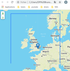
I am a newbie in leaflet programming, and I have an error on showing polygons on IE 11.
My page is very simple and works on Chrome and FireFox. I just draw a point and a polyline.
Expected result is shown in the end of the post.All is fine when I just draw a marker but when I add a polyline, on IE, navigation is fine since the screen map doesn't reach the polyline (high zoom level). As soon as I zoom out to see the polyline, IE11 freezes.
An error is raised in the https://unpkg.com/[email protected]/dist/leaflet.js script (5,61705):
[Impossible to get the property "x" of a null or undefined reference]
on function:
// return closest point on segment or distance to that point
function _sqClosestPointOnSegment(p, p1, p2, sqDist) {
var x = p1.x, // Error raises here
    y = p1.y,
    dx = p2.x - x,
    dy = p2.y - y,
    dot = dx * dx + dy * dy,
    t;

if (dot > 0) {
    t = ((p.x - x) * dx + (p.y - y) * dy) / dot;

    if (t > 1) {
        x = p2.x;
        y = p2.y;
    } else if (t > 0) {
        x += dx * t;
        y += dy * t;
    }
}

dx = p.x - x;
dy = p.y - y;

return sqDist ? dx * dx + dy * dy : new Point(x, y);
}
My code is:
function init() {
  var Produit4 = {
    lat: 52,
    lon: 0,
  };
  var ZoomLevel = 7;
  var mymap = L.map("mapid").setView([Produit4.lat, Produit4.lon], ZoomLevel);
  var MainLayer = L.tileLayer(
    "https://api.mapbox.com/styles/v1/{id}/tiles/{z}/{x}/{y}?access_token=sk.eyJ1IjoiYnJ1bm9nYXJuaWVyIiwiYSI6ImNrYmFzam9hdzA5OW0ycnB2Z2JxeXEwYmcifQ.m0w2z_IIm_M2JdO0W7mJBA",
    {
      attribution:
        "Map data © OpenStreetMap contributors, " +
        "CC-BY-SA, " +
        "Imagery © Mapbox",
      maxZoom: 18,
      id: "mapbox/streets-v11",
      tileSize: 512,
      zoomOffset: -1,
    }
  );
  L.Browser.touch = false;
  MainLayer.addTo(mymap);
  var rectangle = L.polyline([
    [46, -16],
    [62.75, -16],
    [62.75, 13],
    [46, 13],
  ]).addTo(mymap);
  var marker = L.marker([51.5, -0.09]).addTo(mymap);
}
Expected result:


leaflet-src.jsinstead ofleaflet.jswhen debugging in order to get a more readable stack trace.