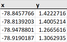
I am trying to import xy coordinates from a CSV file as points into my ArcGIS map. However, when doing so, I get the message "Some of the features have invalid geometry and have been removed from the result" and every single row of my file has failed to get imported.
I have looked into this a little and understand that the format of the coordinates must be in decimal degrees in order to be read. However, I believe this is the case for me. The format of my coordinates is as follows:
I also thought it could be a problem with the coordinate system being used, but I made sure to select the same one that is used on the other layers of the map which I am working on. When using the "Go to XY" tool, the points do show up at the right location, so I believe that they must be expressed in the same system.
I am running out of ideas on what the problem could be. How can I solve this?

