1

I have the following set of data.

Name Easting Northing
Point 1 7675 0576
Point 2 7758 0330
Point 3 7568 0864

I would like to know what coordinate system this data uses, to convert it to latitude and longitude later.

I did not find any documentation about the coordinate system used. The data is from an public university document.

I know the locations are somewhere in Zone 50 of WGS84 (West-Western Australia).

I saw on another question that projfinder.com usually helps in these situations, but I am unsure how to use it or analyse the results it returned.

The data can be found here: https://library.dbca.wa.gov.au/static/FullTextFiles/069766.pdf See pages 178 - 182.

Any ideas?

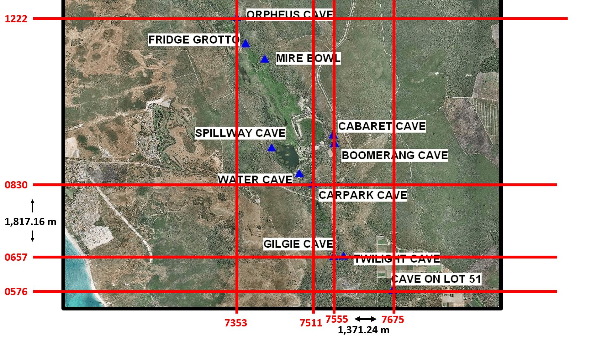
After using a map from here and the original data as seen here (see pages 178-182), I created this image. Does the image help identify the identify the coordinate system used in the set of data?
6
  • 2
    Have you tried multiplying each value by 1,000 and then plot them in Zone 50 to see their locations?
    – PolyGeo
    Commented Nov 26, 2023 at 8:53
  • 4
    You need some more information. Zone 50South WGS84 coordinates in the Australian Continent (EPSG32750) are in the valid range on the Continent SW: 320,300E- 6125, 000N; NW: 181,900E- 7562,000N NE: 816,000E- 7793,000N SE: 785,000E- 6217,000N. No amount of multiplying will solve this- you are missing at least 2 digits in East and 3 in North Commented Nov 26, 2023 at 10:32
  • If, for example, you can find which map these points are located on, that might be enough information to infer the missing digits. What are the locations that these data represent? Commented Nov 30, 2023 at 6:27
  • 1
    can you give a link to the data/document?
    – nmtoken
    Commented Nov 30, 2023 at 8:52
  • @nmtoken, I have edited the question to include a link to the document, see pages 178-182.
    – TigerTen
    Commented Dec 3, 2023 at 14:35

1 Answer 1

1

The data is in the format of MGRS using the datum AGD66, with an accuracy of 10 meters as a result of the four digit long location data. I was able to determine the grid zone and square identifier of the data using this website and knowledge of the general area the locations would be in.

4
  • Your answer could be improved with additional supporting information. Please edit to add further details, such as citations or documentation, so that others can confirm that your answer is correct. You can find more information on how to write good answers in the help center.
    – Community Bot
    Commented Oct 7 at 13:29
  • If this is indeed MGRS, where did you then get info about grid zone designator and square identifier?
    – TomazicM
    Commented Oct 7 at 15:19
  • I have a general idea of where the locations are, and used this website: mappingsupport.com/p2/coordinates-mgrs-gissurfer-maps.html to find the grid zone and square identifier that best fits the area the locations are within.
    – TigerTen
    Commented Oct 8 at 8:40
  • I've updated my answer to add more information.
    – TigerTen
    Commented Oct 8 at 8:47

Your Answer

By clicking “Post Your Answer”, you agree to our terms of service and acknowledge you have read our privacy policy.

Not the answer you're looking for? Browse other questions tagged or ask your own question.