1

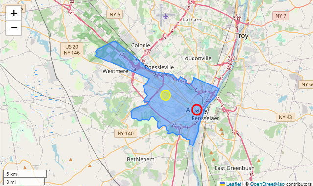
In the following image, I've plotted the administrative boundaries of Albany NY.

enter image description here

The yellow point is the centroid. The red point is the Geocoded location as identified by Nominatim.

Are the points identified by Nominatim hardcoded into a database or are they calculated?

If they are calculated, how are they determined?

Sidenote - my end goal is to identify the "center" of city in a more meaningful way than calculating the centroid. It looks like Nominatim is capable of doing that, but if it's just a hardcoded value that doesn't help me much. I'd like to be able to do it for arbitrary geographic regions.

2
  • 1
    "Albany" is the name of both a county, and a city. The red marker appears to be over the city center. All of these kinds of values are precalculated somewhere, though I'd imagine they'd be different by source. If you want to focus your Question on labeling algorithms, it would still be quite broad and probably unanswerable, but it would be less broad and unanswerable than what you have here.
    – Vince
    Commented Oct 20 at 19:46
  • Can you give me some direction to start? A list of common labeling algorithms? I'm not sure what to search for. "Labeling algorithms" seems to yield results for placing non-overlapping text labels.
    – Jred
    Commented Oct 20 at 21:46

1 Answer 1

3

Nominatim is based on OpenStreetMap data. In your example, "Albany" is identfied as node 316976705: https://www.openstreetmap.org/node/316976705

This isn't calculated, it's declared by the volunteer mappers who contribute to OpenStreetMap. (You could move it if you identified a better location.)

1
  • Thank you. That's what I wanted to know.
    – Jred
    Commented Oct 22 at 14:46

Your Answer

By clicking “Post Your Answer”, you agree to our terms of service and acknowledge you have read our privacy policy.

Not the answer you're looking for? Browse other questions tagged or ask your own question.