Using ArcGIS Desktop v10.2 with an Advanced level license we have georeferenced our engineering drawings in PNG format. Next we have created a polygon layer for every single drawing to see the Area of Interest depicted in the drawing. Is there an automated way to bring individual PNG layers by clicking on their respective polygon? I want a simpler way to add the georeferenced PNG into the map without having to use the classic "add layer" tool, where a user has to find the respective layer in their location on the network.
-
4You should edit your question to specify what software, program, API, etc... you're working with. EX: "We're trying to do this in ArcGIS Desktop v10.2 with an Advanced level license" That way people can make sure an answer to the question actually will help you.– JohnCommented Apr 23, 2014 at 19:15
-
1This question may have an answer that could help you. You'll need a .pwg file in order for the PNG to appear in its correct location on the map. gis.stackexchange.com/questions/88813/…– cbunnCommented Apr 23, 2014 at 20:48
-
Can you elaborate on what you mean by "bring individual PNG layers by clicking on their respective polygon", please?– PolyGeo ♦Commented Apr 25, 2014 at 23:04
-
Have you considered using a mosaic dataset or raster catalog? See: resources.arcgis.com/en/help/main/10.2/index.html#//…– blah238Commented Apr 29, 2014 at 22:16
Add a comment
|
1 Answer
Here is one possible approach:
- add a new field to the polygon layer
- calculate it to hold the path to the image corresponding to each polygon
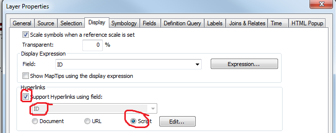
- in the layer Properties panel, choose the Hyperlinks option, specifying the new field, and to run a script

- write a script which uses the AddLayer function, with the path coming from the specified field
This will allow you to add the corresponding image to the map, when clicking on each polygon.
-
I have tried , but my scripts are not working. Do you have a code that you can share? Thanks for your response– AdrianCommented May 2, 2014 at 18:31
