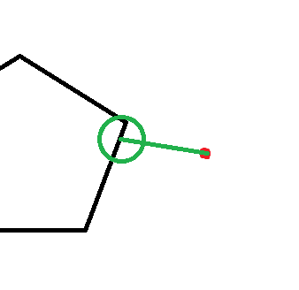
My project is looking at a grid in the ocean. I want to capture each ocean point's distance to the nearest coastline as a weight, and then use buffer to capture the sum of nightlight data within a 1 degree radius buffer around where the line intersects with the coastline. I know how to work with rasters and buffers but would like to know if there is a way to find the point at which the line crosses the polygon. In the picture below, I have data for the red point and the polygon. I want to find the shortest distance to the polygon, identify where that crosses, and then create a buffer (i.e. the green circle) around that point. The data contained in that buffer would ideally then be reflected in the point.
2 Answers
Try something like this.
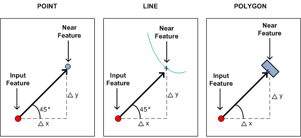
- Use the Generate Near Table analysis function. This gets you the distance to the closest line on the Polygon as in your diagram.

- Join this information back to the the original points file.
- Build the new point based on the angle and the distance you now have in the original point layer. Something like this in the field calculator after adding an x1 and y1 (double) field.
You could then calculate the new point coordinates using the Field Calculator with two simple geometric expressions, one for X and another for Y.
x1 = x0 + distance*cos(bearing)
y1 = y0 + distance*sin(bearing)
- Create a new point shapefile based on x1 and y1 (add x,y data).
- Buffer the new points carrying across the original points ID.
- Use the original point ID in the buffer to join the buffer info back to the original points file.
For step 3 you could also create a line from the distance and angle and then convert the end to a point.
I am trying to coin a GIS phrase for this type of action "Create Shadow Points" and maybe later a tool with a handful of differing options (x & y offset and angle, on closest feature in direction x, and others). When you want to create one set of points from another with a 1-1 match and all that differs is the location of the second point, i.e the shadow.
-
Thanks much! "Create Shadow Points" seems like a good descriptor - I struggled with trying to name this process.– KristaRCommented Jan 11, 2016 at 22:22
-
start using it so I can build momentum. Commented Jan 11, 2016 at 22:25
-
If you have an Advanced ArcGIS license, the Near tool will add the closest Point as Near_X,Near_Y coordinates to the input attribute table. The Make XY Event Layer tool can be used to create a Point Layer from the Near_X,Near_Y values. You must copy the point layer to disc to preserve it because it is only in_memory, FYI. Another option is found in the menu File, Add Data, Add XY Data. Lastly, you can buffer the Point Feature class.

