2

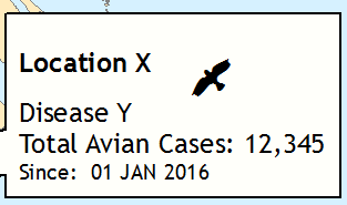
I am attempting to offset an ESRI character (the bird in the image) to be bottom-alignment with Location X. Is there any type of formatting tag that might allow me to shift the character upward? I already tried Superscript and it shrunk the symbol down too much. The input text is below:

<BOL>Location X</BOL><FNT name="ESRI Environmental &amp; Icons" size="30"> )</FNT>
Disease Y
Total Avian Cases: 12,345
<FNT size="8">Since:  01 JAN 2016 </FNT>

Textbox input

3
  • superscript with a larger font size?
    – Midavalo
    Commented Feb 12, 2016 at 20:52
  • Superscript causes the symbol to shrink down. It also shifts the symbol up too high (pretty much the opposite of the current position).
    – Map Man
    Commented Feb 16, 2016 at 17:59
  • Have you considered having the Text Box contain only the text, and then adding a separate graphic element that you position precisely where you want it?
    – PolyGeo
    Commented Mar 3, 2016 at 3:38

1 Answer 1

1

My solution was a little unorthodox, but it got the desired result without requiring an additional graphic element to manually offset an icon--this product gets updated very frequently.

1) I went to http://www.myscriptfont.com/ and downloaded the custom font creation form

2) I opened the pdf file in Adobe (any illustrator would work), then I added .png silhouette images in the character boxes. I made sure to offset them (a little on the +y side).

3) Upload the form back to the myscriptfont site and download the resulting .ttf file-- I named it "TreeBird1".

4) Drop the file into my fonts folder on the C: drive.

5) Restart arc, then just use formatting tags to activate the custom font. In this case, a bird was equivalent to the letter "D" in my new file.

<BOL>Country X</BOL>
Bird Disease <FNT name="TreeBird1" size="16"> D</FNT>
Total Avian Cases: <BOL><CLR red="233">15</CLR></BOL> (<BOL><CLR red="233">+3</CLR></BOL>)
<FNT size="8">Since:  01 JAN 2016 </FNT>

enter image description here

Pretty much every silhouette image on the internet can now be added in-line to ArcMap without an offset issue. Birds, trees, mushrooms, anything.
Your Answer

By clicking “Post Your Answer”, you agree to our terms of service and acknowledge you have read our privacy policy.

Not the answer you're looking for? Browse other questions tagged or ask your own question.