3

I've tried converting the following lat/long data into Google Earth but the intersection doesn't show up on my map when I try entering them.

What does N87° 40'20"E convert to?

What does N1° 49'33"W convert to?

radius compass site map

UPDATE

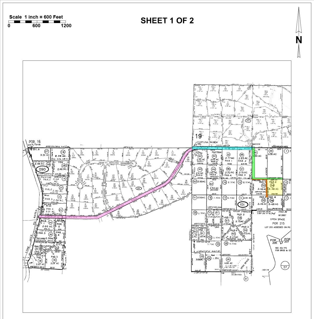
This is the only other map I have of the area. The zoom in is located using the orange square in the image below. Not finding a control point, could be off the map as it seems this is piecemeal and a custom map from the original.

site map

5
  • 3
    Looks like bearing and distance to me, but without knowing where the source point is, it may not be enough to generate a real world coordinate.
    – Vince
    Commented Jul 18, 2016 at 23:10
  • 2
    I agree, these aren't positional coordinates but bearings and distances used to draw in boundary lines. You'd need to know a point of origin (often shown in notes on a lot/boundary plan like the partial one in your screenshot)
    – Midavalo
    Commented Jul 18, 2016 at 23:33
  • You might visit sdgis.sandag.org and search for parcel No 2641015400. The site provides latlon coordinates at the mouse position. They also offer data for download at sangis.org/download/index.html, but you are requested for login.
    – AndreJ
    Commented Jul 21, 2016 at 8:10
  • According to this guide for San Diego County Parcel Identification: arcc.sdcounty.ca.gov/Documents/parcel-map-guide.pdf the parcel consists of Book-Block-Parcel, in your case this half of the page is missing the Book which is likely on the other half, so your Parcel would be ###-101-54.
    – kttii
    Commented Jul 21, 2016 at 13:56
  • if you know the street address, then you could find the parcel number: arcc.sdcounty.ca.gov/Pages/Property-Sales.aspx
    – kttii
    Commented Jul 21, 2016 at 14:11

2 Answers 2

6

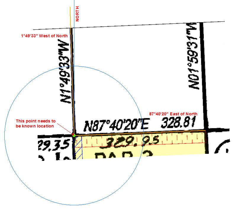
I don't believe you can calculate a position from these values. These look to be bearings and distances - a direction around a circle from a known location.

The known location could be anywhere in the world, and the boundary lines are drawn in the direction and distance listed from that known location. These are used to create lot boundaries.

Basically it's something like this (probably over-simplified). The N represents the compass bearing the values are based on. I believe these are usually either North or South (but have seen some with East and West). In this case, as it's N for North, the angles are to the E East or W West of that North bearing. The 328.81 is the distance from your known location, in the direction of your bearing.

The point of intersection needs to be known. Usually a lot plan will have an origin point to base the rest of the lines from, and then subsequent lines are started from the end of the previous line. If you don't know where that origin point is, then you may be out of luck.
enter image description here

It's been a very long time since I've input boundaries from plans like this, and I only ever did it while learning, so I may be wrong with some of it, but I think I got the basics right here.

6
  • 1
    I agree and would add that a bearing can be any combination of N#E, N#W, S#E, S#W. The bearing is in Degrees/Minutes/Seconds but may be converted to Decimal (N87°40'20"E = N87.67222222E) or even Degree-Minute decimal (N87°40.33333333)... but it is still a bearing and requires a known starting point which is likely described further away from the lines you are sharing here. Think of it like like drawing a square where you never lift up your pencil... you have to start with your pencil on the paper somewhere. See academic.brooklyn.cuny.edu/geology/leveson/core/linksa/…
    – kttii
    Commented Jul 19, 2016 at 13:54
  • 1
    @Tiger Danky follow your lines to the South or West to locate the starting point.
    – kttii
    Commented Jul 19, 2016 at 14:01
  • thx everyone. makes so much more sense now. Commented Jul 19, 2016 at 16:02
  • @Tiger Danky so did you find the start point in your file?
    – kttii
    Commented Jul 20, 2016 at 17:18
  • 1
    Your new image is here on google maps - all you need to do is find a known coordinate from the location map and your image and use the bearings and distances to locate your area of interest (if it's not already easily identifiable from google maps).
    – Midavalo
    Commented Jul 20, 2016 at 23:21
-2

I take it that looks like standard latitude and longitude, in degrees - minutes - seconds (N87 degrees, 40 minutes and 20 seconds). Apparently this can be converted to decimal using the following:

Decimal Degrees = Degrees + minutes/60 + seconds/3600

Though I'm unsure if this is correct in your particular case (and also because I haven't done that in a while).

1
  • 4
    NblahE and NblahW are not simple DMS designations.
    – Vince
    Commented Jul 18, 2016 at 23:34

Your Answer

By clicking “Post Your Answer”, you agree to our terms of service and acknowledge you have read our privacy policy.

Not the answer you're looking for? Browse other questions tagged or ask your own question.