3

I have two polygon layers, one is from natural earth data (Administrative 1 division) and the other is a polygon layer with some historical regions in Europe. As you can see in the image attached there are some areas which still has the same boundary, but since these two layers come from different sources they don't match up, is there a way I can match this automatically in QGIS 3.10?

I tried the snap geometries to layer tool and it just didn't work. (either it caused QGIS to crash, or the output was just the same as the input).

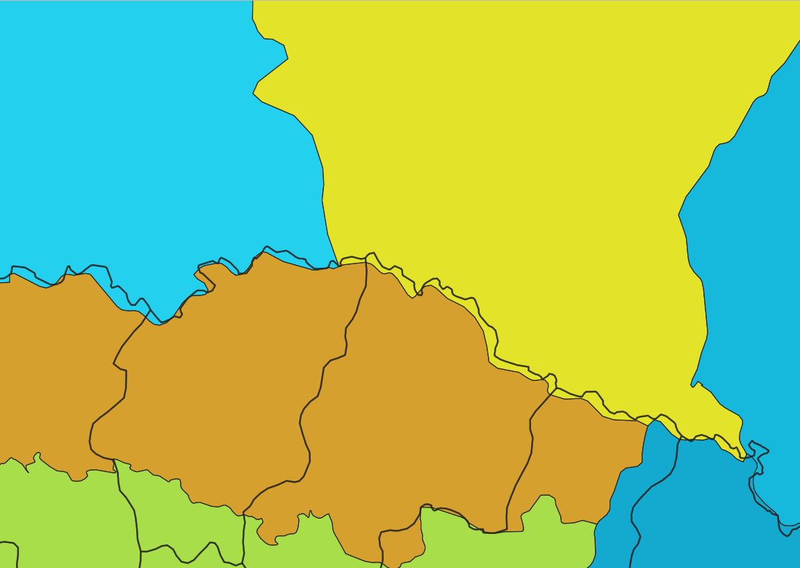
enter image description here

5
  • you may use vector difference to "align" the layers
    – Elio Diaz
    Commented Jul 20, 2020 at 19:19
  • 1
    You could run a union or intersect vector overlay, and then manually select and merge with the main polys the small polygons created where each layer's polygons edges differed from the others. But that merging could be a lot of work if there are many small sliver polys. If you don't care which layer's lines are the best you could calculate the area of the polygons, select for those below a certain size on the assumption they are the newly created slivers, and then run the Eliminate selected polygons tool on that.
    – John
    Commented Jul 20, 2020 at 20:34
  • @johns Thanks! i did that actually... the problem there are to many polygons and it will take me forever to clean it up... i also did the eliminate selected polygons, but i want specific it should match the layer from natural earth data cuz i want to use their rivers, lakes etc. for my map... ;( Commented Jul 20, 2020 at 21:55
  • 1
    @Yonoson, could you instead run a spatial join (join attributes by location) with your base layer being the natural earth data and the join being the historical? That would put the historical regions information into the joined layer, and then you could use that for your ultimate goal? Or if you ran one of the overlays, you might be able to run a dissolve using the natural earth unique values in one field and keeping the historical values, and then use that in your next step. You might indicate what you ultimately want to do with the layer or layers.
    – John
    Commented Jul 21, 2020 at 13:11
  • @johns, Thanks! this actually helped me a lot! I ran a spatial join then i dissolved with the fid of the historical regions, this helped me with polygons who are in the same historical region. for polygons who are between two historical regions i had to manually split using the tracing tool and by tracing only the historical regions layer. Thanks again! Commented Jul 22, 2020 at 16:11

1 Answer 1

1

You can also use the Move Feature(s) tool to move your polygons. Select the polygons you want to move, than activate the tool and move the selected polygons with the mouse. If you enabled snapping, you can snap the moved polygons to the other ones so that they overlap perfectly.

If not visible, active Advanced Digitizing Toolbar in Menu View / Toolbar.

Your Answer

By clicking “Post Your Answer”, you agree to our terms of service and acknowledge you have read our privacy policy.

Not the answer you're looking for? Browse other questions tagged or ask your own question.