5

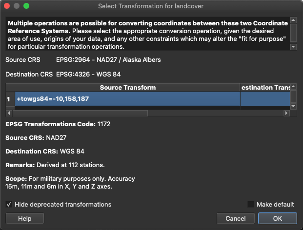
I've installed QGIS and downloaded the sample files (I'm on a Mac). Following the documentation for getting started I double-click on the landcover.img file which is supposed to load in the background. But I get a "Select Transformation for landcover" dialog box which is not mentioned in the documentation and I have no idea what to select.

Select Transformation for lancover

This is probably a good learning opportunity but I fear that I am on a steep curve.

2 Answers 2

7

If you are not sure, choose whatever setting you can select, best accept what QGIS proposes as default. In most cases, it should produce an acceptable result (from documentation):

QGIS will attempt to use the most accurate transformation available.

In Menu Settings / Options / Transformations you probably have checked the box next to Ask for datum transformation if several are available. Deactivate it so that QGIS will automatically choose without asking anymore.

This is a "quick and dirty" approach, but you don't necessarily have to bother if exact precision is not critical for what you want to achieve. If you are new to QGIS (as you suggest), better make yourself comfortable with the basic functions before diving deeper into the technical details.

For background information: these transformations are different (mathematical) procedures to convert coordinates from one CRS (the CRS of the layer you load) to another CRS: the CRS the data will be visualized, that means the project CRS. Thus, if you want to avoid transformation, you have basically two options:

  1. Set the project CRS to the CRS of the layer you load. However, if you have several layers with different CRS, you can't avoid transformation for all layers.

  2. Reproject your layers. However, in this case your layer will be transformed during the process.

As the transformation of coordinates between diffents CRS (implying different spheroids, datums etc.) is not trivial and often cannot be accomplished with 100% accuracy, there are different algorithms available for an approximation of the coordinates in one CRS to the coordinates in another one. That means that using different transformations, you will get diffent coordinates, at least in the details.

So if precision is critical for what you want to do, you should dive deeper into the theoretical background of coordinate transformation. It's a rather mathematical topic. Imagine that there are different ways of projecting points from a spheroid to a planar map canvas. So you basically should understand the maths behind that operation and how you can approximate the result from one projection to the result of another projection.

See here for an example: http://www.crs-geo.eu/changing-crs.htm

You can also consult the background in the documentation of ESRI's ArcGIS. Even if it's not QGIS, the theory and concepts are the same: https://pro.arcgis.com/en/pro-app/latest/help/mapping/properties/coordinate-systems-and-projections.htm

3
  • Thanks for the detailed response. It's very helpful to understand that this is about coordinate transformations. At this point, however, my goal is just to follow along with the documentation and get a feel of how the program works. So I guess clicking "OK" is the best solution for now. But I can't help but wonder why this would be necessary for a sample file and the default installation. Ah, well, I'll keep plugging along.
    – Mike
    Commented Jan 18, 2021 at 17:16
  • See updated answer, second paragraph as for why you got this message. And yes: for the moment it's probably best to just click it, bat bear it mind for later.
    – Babel
    Commented Jan 18, 2021 at 17:23
  • What is also relevant: When using pyqgis and this is checked: it will not give you any warning and the results of any reprojection might be just wrong...
    – Riccardo
    Commented Aug 26 at 20:16
2

Here's what I've discovered in case it helps other newbies: When you first open QGIS don't click the New Project Template pane. Instead, got to the New Project icon on the menu bar (blank sheet of paper). Then select Project -> Properties. On the left hand pane select the third icon (CRS). At the top of the dialog box type 2964 in the Filter field. This will return NAD27/Alaska Albers, with Authority ID EPSG:2964. Select this and hit OK. Now your new project is using the same coordinate system as the sample file and there is no longer a Transform issue.

Mike

1
  • 1
    If you want to make settings once and for all, not just for each project separately, go to Menu Settings / Options / CRS and check the box near Use CRS from first layer added. When you add a new layer to an empty project (e.g. drag and drop the file to the QGIS main window), the project wil be set automatically to the CRS of this layer.
    – Babel
    Commented Jan 18, 2021 at 20:24

Your Answer

By clicking “Post Your Answer”, you agree to our terms of service and acknowledge you have read our privacy policy.

Not the answer you're looking for? Browse other questions tagged or ask your own question.