I have a layer on GeoServer which includes lots of organizations. Different organizations can be on the same point. SLD style for this layer:
<?xml version="1.0" encoding="UTF-8"?>
<sld:StyledLayerDescriptor
    xmlns="http://www.opengis.net/sld"
    xmlns:sld="http://www.opengis.net/sld"
    xmlns:gml="http://www.opengis.net/gml"
    xmlns:ogc="http://www.opengis.net/ogc" version="1.0.0">
    <sld:Name>hybrid_org</sld:Name>
    <sld:NamedLayer>
        <sld:Name>firms_2gis_info</sld:Name>
        <sld:UserStyle>
            <sld:Name>Default Styler</sld:Name>
            <sld:FeatureTypeStyle>
                <sld:Name>firms_2gis_info</sld:Name>
                <sld:Title>MBStyle firms_2gis_info</sld:Title>
                <sld:Abstract>Generated for firms_2gis_info</sld:Abstract>
                <sld:Rule>
                    <sld:Name>firms_2gis_info</sld:Name>
                    <ogc:Filter>
                        <ogc:PropertyIsEqualTo>
                            <ogc:Function name="in">
                                <ogc:PropertyName>layer_id</ogc:PropertyName>
                                <ogc:Literal>poi_emergency_01</ogc:Literal>
                                <ogc:Literal>poi_culture_02</ogc:Literal>
                                <ogc:Literal>poi_culture_03</ogc:Literal>
                                <ogc:Literal>poi_leisure_02</ogc:Literal>
                                <ogc:Literal>poi_sport_04</ogc:Literal>
                                <ogc:Literal>poi_leisure_01</ogc:Literal>
                            </ogc:Function>
                            <ogc:Literal>false</ogc:Literal>
                        </ogc:PropertyIsEqualTo>
                    </ogc:Filter>
                    <sld:MinScaleDenominator>266.5911979441132</sld:MinScaleDenominator>
                    <sld:MaxScaleDenominator>17061.836668423246</sld:MaxScaleDenominator>
                    <sld:TextSymbolizer uom="http://www.opengeospatial.org/se/units/pixel">
                        <sld:Label>
                            <ogc:PropertyName>feature_name</ogc:PropertyName>
                        </sld:Label>
                        <sld:Font>
                            <sld:CssParameter name="font-family">
                                <ogc:Function name="fontAlternatives">
                                    <ogc:Literal>OpenSans-Bold</ogc:Literal>
                                </ogc:Function>
                            </sld:CssParameter>
                            <sld:CssParameter name="font-size">10</sld:CssParameter>
                            <sld:CssParameter name="font-style">normal</sld:CssParameter>
                            <sld:CssParameter name="font-weight">normal</sld:CssParameter>
                        </sld:Font>
                        <sld:LabelPlacement>
                            <sld:PointPlacement>
                                <sld:AnchorPoint>
                                    <sld:AnchorPointX>0.5</sld:AnchorPointX>
                                    <sld:AnchorPointY>1.0</sld:AnchorPointY>
                                </sld:AnchorPoint>
                                <sld:Displacement>
                                    <sld:DisplacementX>
                                        <ogc:Mul>
                                            <ogc:Literal>10</ogc:Literal>
                                            <ogc:Literal>0</ogc:Literal>
                                        </ogc:Mul>
                                    </sld:DisplacementX>
                                    <sld:DisplacementY>
                                        <ogc:Mul>
                                            <ogc:Literal>10</ogc:Literal>
                                            <ogc:Mul>
                                                <ogc:Literal>-1</ogc:Literal>
                                                <ogc:Literal>0.5</ogc:Literal>
                                            </ogc:Mul>
                                        </ogc:Mul>
                                    </sld:DisplacementY>
                                </sld:Displacement>
                            </sld:PointPlacement>
                        </sld:LabelPlacement>
                        <sld:Halo>
                            <sld:Radius>0.5</sld:Radius>
                            <sld:Fill>
                                <sld:CssParameter name="fill">#131813</sld:CssParameter>
                            </sld:Fill>
                        </sld:Halo>
                        <sld:Fill>
                            <sld:CssParameter name="fill">#FFFFFF</sld:CssParameter>
                        </sld:Fill>
                        <sld:Graphic>
                            <sld:ExternalGraphic>
                                <sld:OnlineResource
                                    xmlns:xlink="http://www.w3.org/1999/xlink" xlink:type="simple" xlink:href="image"/>
                                    <sld:Format>mbsprite</sld:Format>
                                </sld:ExternalGraphic>
                                <sld:AnchorPoint>
                                    <sld:AnchorPointX>0.5</sld:AnchorPointX>
                                    <sld:AnchorPointY>0.0</sld:AnchorPointY>
                                </sld:AnchorPoint>
                                <sld:Displacement>
                                    <sld:DisplacementX>
                                        <ogc:Mul>
                                            <ogc:Literal>0.5</ogc:Literal>
                                            <ogc:Literal>0</ogc:Literal>
                                        </ogc:Mul>
                                    </sld:DisplacementX>
                                    <sld:DisplacementY>
                                        <ogc:Mul>
                                            <ogc:Literal>0.5</ogc:Literal>
                                            <ogc:Mul>
                                                <ogc:Literal>-1</ogc:Literal>
                                                <ogc:Literal>0</ogc:Literal>
                                            </ogc:Mul>
                                        </ogc:Mul>
                                    </sld:DisplacementY>
                                </sld:Displacement>
                            </sld:Graphic>
                            <sld:Priority>1000</sld:Priority>
                            <sld:VendorOption name="repeat">0</sld:VendorOption>
                            <sld:VendorOption name="conflictResolution">true</sld:VendorOption>
                            <sld:VendorOption name="graphic-resize">NONE</sld:VendorOption>
                            <sld:VendorOption name="partials">true</sld:VendorOption>
                            <sld:VendorOption name="graphic-margin">0</sld:VendorOption>
                            <sld:VendorOption name="spaceAround">25</sld:VendorOption>
                            <sld:VendorOption name="autoWrap">150.0</sld:VendorOption>
                            <sld:VendorOption name="graphicPlacement">INDEPENDENT</sld:VendorOption>
                            <sld:VendorOption name="labelObstacle">false</sld:VendorOption>
                            <sld:VendorOption name="fallbackOnDefaultMark">false</sld:VendorOption>
                        </sld:TextSymbolizer>
                    </sld:Rule>
                </sld:FeatureTypeStyle>
            </sld:UserStyle>
        </sld:NamedLayer>
    </sld:StyledLayerDescriptor>
When i try to seed and cache with help of mapproxy it gives bad results. It cuts images on tile edges. Mapproxy settings like meta_tile_size and meta_buffer helps particullary. Somwhere it helps, somewhere problems are still here.
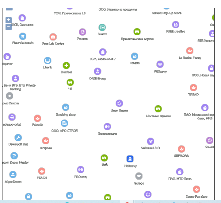
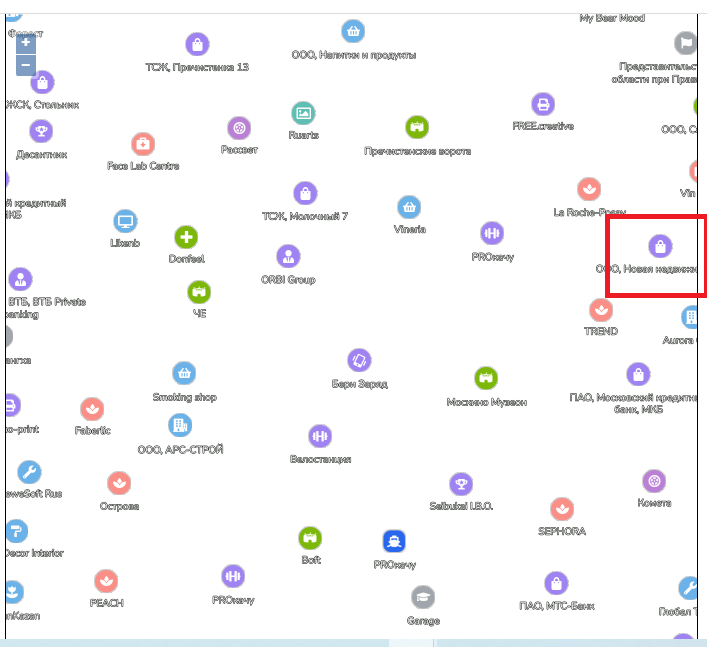
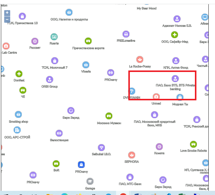
I understand why this happens. It happens because conflict resolution is different on different tiles. Example:
On this tile the organization in red box is visible, because the neighbour organization is not visible. If we move a little bit right, neighbour organization is visible and conflict resolution hide the first irganization. It means, that the organization will be cut on the tile edge.
I understand, that meta_buffer of mapproxy should do the trick, but somewhere it helps and somewhere not.
Mapproxy - v1.14.0 Geoserver - v2.17.2
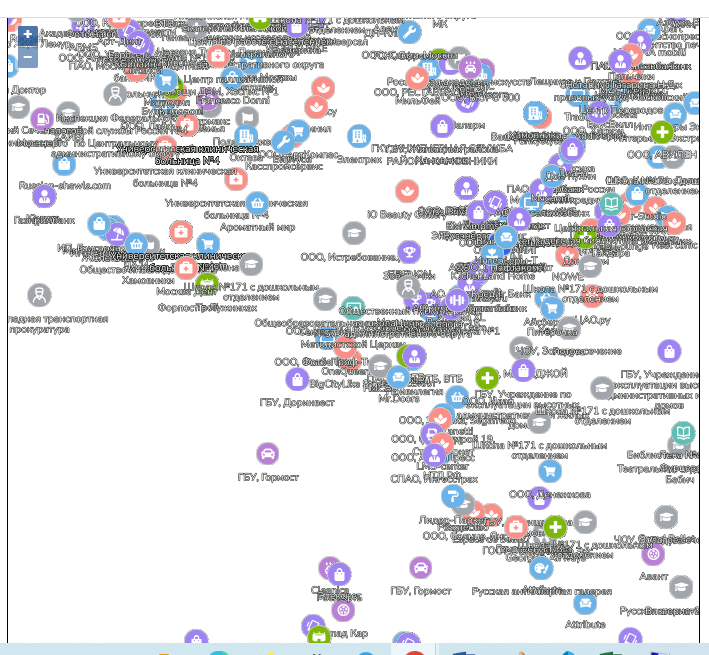
After disabling conflictResolution i have this:


