I have a scan of a historical map in pdf. I converted it in to png as well as tif and then georeferenced it. However, as soon as I load the image (both png and tif) in to the georeferencing tool the resolution is degrading. Does somebody know why this is happening and how to prevent it? I use QGIS.
-
1Are you using a CRS that fits the georeferenced imagery?– bugmenot123Commented Nov 23, 2023 at 11:09
-
Does the map look better when you zoom close enough for inserting the ground control points?– user30184Commented Nov 23, 2023 at 11:14
-
2Maybe posting a screenshot or the resulting georeferenced image could help understanding the problem– BabelCommented Nov 23, 2023 at 14:11
Add a comment
|
1 Answer
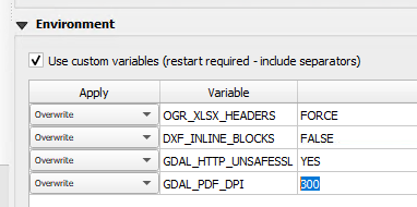
You can directly load your PDF into the Georeferencer canvas. QGIS uses the GDAL config option GDAL_PDF_DPI to set the resolution of the PDF. The default value is 150. You can increase this value with an System environment variable (i.e. GDAL_PDF_DPI=300): Settings>Options...>System>Environment
-
My PDF has a good resolution, therefore I dont need to improve it. I need to convert it in to png and then georeference it, so for me only the resolution of the png/tif is of relevance.– LinaCommented Nov 24, 2023 at 15:04

