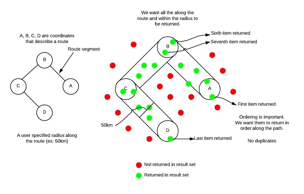
I am unsure of the best approach to this problem. I can think of some ways of doing it which I will list below but I am looking for the best and most efficient way of doing this.
Problem
- Given a variable number of points, create a "route" or line between the points.
- Create a bounding box (of 50km[arbitrary]) around the route.
- Return all points within this bounding box
- Points must be returned in order along the route (A->D)
Note: The radius does not have to be circles. A,B,C,D can use rectangular bounding boxes.

Data
- Table with points (x,y - technically lat/lon)
- Input points to create a route
- Distance from route to include points
We are using PostgreSQL (8.4) and PostGIS (1.3.6) and Python.
This is the solution I came up with. Thoughts? Ideas? Input?
Possible Solution
- Create three polygon "tubes" (A->B, B->C, C->D)
- Filter points to only those in the polygons.
- Subtract B->C from A->B so the polygons do not overlap (no duplicates)
- Subtract C->D from B->C so the polygons do not overlap (no duplicates)
- For each polygon
- Calculate vector (A->B, B->C, C->D)
- Find furthest point opposite of vector in the polygon.
- Calculate distance from furthest point to each site in polygon.
- Return points in order of distance (smallest -> largest)
- Join all the points together (A->B points, B->C points, C->D points)
Solution
My approach was naive, after taking some time and looking at the PostGIS methods I came up with this single SQL call. Note its specific to our database but might help someone in the future. Im sure it could be improved as well.
    SELECT aerodrome_id
    FROM
      geo_aerodromecustom_view,
      (SELECT ST_Buffer(
          ST_Transform(
              (SELECT ST_MakeLine(geom)
              FROM
                  (SELECT geom
                  FROM geo_aerodromecustom_view
                  WHERE aerodrome_id IN ('CYOW','CYVR')
                  ORDER BY CASE aerodrome_id WHEN 'CYOW' THEN 1 WHEN 'CYVR' THEN 2 ELSE 5 END
                  ) sites
              ),
              900913
          ),
          50000) as geo
      ) as line
    WHERE ST_Intersects(ST_Transform(geom, 900913), line.geo)
    ORDER BY ST_Line_Locate_Point(
      ST_Transform(
          (SELECT ST_MakeLine(geom)
           FROM
              (SELECT geom
               FROM geo_aerodromecustom_view
               WHERE aerodrome_id IN ('CYOW','CYVR')
               ORDER BY CASE aerodrome_id WHEN 'CYOW' THEN 1 WHEN 'CYVR' THEN 2 ELSE 5 END
              ) sites
          ),
          900913
      ),
      ST_Transform(geom, 900913)
    )
I had to project the data because I am using PostGIS 1.3.4 which doesnt support Geography type.
Basically what I am doing is I am using ST_MakeLine and a query to locate "aerodromes" and return their geometry.
I had to order them (using the CASE directive) so that the line would be connected in the right order.
I then project and buffer this line to create a Polygon that I can then use to see what other aerodromes intersect with the buffered polygon.
Using the unbuffered line (route) and the call ST_Line_Locate_Line I then order the discovered aerodromes as they appear appear along the path.
