1

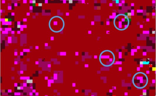
portion of an image, need to remove pixels inside the ring and get pure brown color

I am processing a LandSAT image for geological purposes. After some processing there are so many sandy dots in the image. To get clear geological formation as a polygon I want to remove small sandy pixels. After 'majority' filter, by 3x3, 5x5, 9x9 many of them still remaining.

If you have any better idea for how to remove them the sandy, please share!

3
  • 1
    can you post an example?
    – dowi
    Commented Jul 2, 2014 at 6:54
  • here i put an image of processing.
    – peter
    Commented Jul 2, 2014 at 7:21
  • There is a related post that may help you: gis.stackexchange.com/a/91610/8104
    – Aaron
    Commented Jul 9, 2014 at 19:50

2 Answers 2

2

so i guess this is a classified image?

i can think of two more ideas :

1. i think for each class you can (start from biggest to lowest class) you can do morphological operations - open -> close (dilate -> erode).

2. treat them as polygons, find holes and remove them

you can do this for example in matlab

0

You need to define the Minimum Mapping Unit (MMU). Also, treating 'clusters' of classified regions as polygons can help. as you are in Imagine I will provide software specific directions

  • apply focal majority filter (makes image polygon-like)

Raster>Thematic>Neighborhood>Majority (I like the 5x5)

  • 'Clump' the filtered image

Raster>Thematic>Clump (ignore zero in output stats)

  • sieve the results (This is what you where really looking for)

Raster>Thematic>Sieve -- Specify a minimum size of region to retain (i.e. 25 pixels) click OK!

Now, you will probably want to recode the image.

Happy Mapping!

Your Answer

By clicking “Post Your Answer”, you agree to our terms of service and acknowledge you have read our privacy policy.

Not the answer you're looking for? Browse other questions tagged or ask your own question.