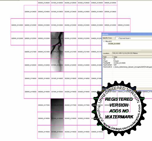
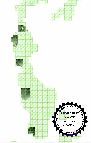
I am having a major issue with the Mosaic to New Raster tool when importing ASC files. It processes the first few files but not all of them. I thought it was a space issue and tried to split the input but this doesn’t help.
For ex the output when I run the tool directly and in the python window is out1
 [code]
Direct tool
arcpy.MosaicToNewRaster_management("L:/Data_Admin/temp_dataset_storage/LiDAR/FinalSupply/Atherton_Tolga_Walkamin_Mareeba_Bilwon/ASCII_DEM/asc/331000_8120000_1k_1m_DEM_ESRI.asc;L:/Data_Admin/temp_dataset_storage/LiDAR/FinalSupply/Atherton_Tolga_Walkamin_Mareeba_Bilwon/ASCII_DEM/asc/331000_8121000_1k_1m_DEM_ESRI.asc;L:/Data_Admin/temp_dataset_storage/LiDAR/FinalSupply/Atherton_Tolga_Walkamin_Mareeba_Bilwon/ASCII_DEM/asc/331000_8122000_1k_1m_DEM_ESRI.asc;L:/Data_Admin/temp_dataset_storage/LiDAR/FinalSupply/Atherton_Tolga_Walkamin_Mareeba_Bilwon/ASCII_DEM/asc/331000_8123000_1k_1m_DEM_ESRI.asc;L:/Data_Admin/temp_dataset_storage/LiDAR/FinalSupply/Atherton_Tolga_Walkamin_Mareeba_Bilwon/ASCII_DEM/asc/331000_8124000_1k_1m_DEM_ESRI.asc;L:/Data_Admin/temp_dataset_storage/LiDAR/FinalSupply/Atherton_Tolga_Walkamin_Mareeba_Bilwon/ASCII_DEM/asc/331000_8125000_1k_1m_DEM_ESRI.asc;L:/Data_Admin/temp_dataset_storage/LiDAR/FinalSupply/Atherton_Tolga_Walkamin_Mareeba_Bilwon/ASCII_DEM/asc/331000_8126000_1k_1m_DEM_ESRI.asc;L:/Data_Admin/temp_dataset_storage/LiDAR/FinalSupply/Atherton_Tolga_Walkamin_Mareeba_Bilwon/ASCII_DEM/asc/331000_8127000_1k_1m_DEM_ESRI.asc;L:/Data_Admin/temp_dataset_storage/LiDAR/FinalSupply/Atherton_Tolga_Walkamin_Mareeba_Bilwon/ASCII_DEM/asc/331000_8128000_1k_1m_DEM_ESRI.asc;L:/Data_Admin/temp_dataset_storage/LiDAR/FinalSupply/Atherton_Tolga_Walkamin_Mareeba_Bilwon/ASCII_DEM/asc/331000_8129000_1k_1m_DEM_ESRI.asc","P:/2011/Job_106_TRC_FireHazard_Mapping/Working/data/1_Mosaic DEM","Mosaic2","PROJCS['GDA_1994_Transverse_Mercator',GEOGCS['GCS_GDA_1994',DATUM['D_GDA_1994',SPHEROID['GRS_1980',6378137.0,298.257222101]],PRIMEM['Greenwich',0.0],UNIT['Degree',0.0174532925199433]],PROJECTION['Transverse_Mercator'],PARAMETER['False_Easting',500000.0],PARAMETER['False_Northing',10000000.0],PARAMETER['Central_Meridian',147.0],PARAMETER['Scale_Factor',0.9996],PARAMETER['Latitude_Of_Origin',0.0],UNIT['Meter',1.0]]","8_BIT_UNSIGNED","#","1","LAST","FIRST")
[/code]
Python Code - Direct in Arcmap python window
[code]
>>> List

['L:\\Data_Admin\\temp_dataset_storage\\LiDAR\\FinalSupply\\Atherton_Tolga_Walkamin_Mareeba_Bilwon\\ASCII_DEM\\asc\\331000_8115000_1k_1m_DEM_ESRI.asc', 'L:\\Data_Admin\\temp_dataset_storage\\LiDAR\\FinalSupply\\Atherton_Tolga_Walkamin_Mareeba_Bilwon\\ASCII_DEM\\asc\\331000_8116000_1k_1m_DEM_ESRI.asc', 'L:\\Data_Admin\\temp_dataset_storage\\LiDAR\\FinalSupply\\Atherton_Tolga_Walkamin_Mareeba_Bilwon\\ASCII_DEM\\asc\\331000_8117000_1k_1m_DEM_ESRI.asc', 'L:\\Data_Admin\\temp_dataset_storage\\LiDAR\\FinalSupply\\Atherton_Tolga_Walkamin_Mareeba_Bilwon\\ASCII_DEM\\asc\\331000_8118000_1k_1m_DEM_ESRI.asc', 'L:\\Data_Admin\\temp_dataset_storage\\LiDAR\\FinalSupply\\Atherton_Tolga_Walkamin_Mareeba_Bilwon\\ASCII_DEM\\asc\\331000_8119000_1k_1m_DEM_ESRI.asc', 'L:\\Data_Admin\\temp_dataset_storage\\LiDAR\\FinalSupply\\Atherton_Tolga_Walkamin_Mareeba_Bilwon\\ASCII_DEM\\asc\\331000_8120000_1k_1m_DEM_ESRI.asc', 'L:\\Data_Admin\\temp_dataset_storage\\LiDAR\\FinalSupply\\Atherton_Tolga_Walkamin_Mareeba_Bilwon\\ASCII_DEM\\asc\\331000_8121000_1k_1m_DEM_ESRI.asc', 'L:\\Data_Admin\\temp_dataset_storage\\LiDAR\\FinalSupply\\Atherton_Tolga_Walkamin_Mareeba_Bilwon\\ASCII_DEM\\asc\\331000_8122000_1k_1m_DEM_ESRI.asc', 'L:\\Data_Admin\\temp_dataset_storage\\LiDAR\\FinalSupply\\Atherton_Tolga_Walkamin_Mareeba_Bilwon\\ASCII_DEM\\asc\\331000_8123000_1k_1m_DEM_ESRI.asc', 'L:\\Data_Admin\\temp_dataset_storage\\LiDAR\\FinalSupply\\Atherton_Tolga_Walkamin_Mareeba_Bilwon\\ASCII_DEM\\asc\\331000_8124000_1k_1m_DEM_ESRI.asc', 'L:\\Data_Admin\\temp_dataset_storage\\LiDAR\\FinalSupply\\Atherton_Tolga_Walkamin_Mareeba_Bilwon\\ASCII_DEM\\asc\\331000_8125000_1k_1m_DEM_ESRI.asc']

>>> arcpy.MosaicToNewRaster_management(List, v1_Mosaic_DEM, 'Name',"PROJCS['GDA_1994_Transverse_Mercator',GEOGCS['GCS_GDA_1994',DATUM['D_GDA_1994',SPHEROID['GRS_1980',6378137.0,298.257222101]],PRIMEM['Greenwich',0.0],UNIT['Degree',0.0174532925199433]],PROJECTION['Transverse_Mercator'],PARAMETER['False_Easting',500000.0],PARAMETER['False_Northing',10000000.0],PARAMETER['Central_Meridian',147.0],PARAMETER['Scale_Factor',0.9996],PARAMETER['Latitude_Of_Origin',0.0],UNIT['Meter',1.0]]", "32_BIT_FLOAT", "", "1", "LAST", "FIRST")

<Result 'P:\\2011\\Job_106_TRC_FireHazard_Mapping\\Working\\data\\1_Mosaic DEM\\Name'>
[/code]
So both processes are loading all the required asc files into the tool but they are not being merged and weirdly the result DEM’s are in different zones of the band.
I tried to break the files up in to bands as I thought it was a space issue but actually I need each mosaic to be made of about 100 tiles. When I tried the process by splitting into bands, it just processed the first few tiles of each region as in the graphic above.
The full script I need to run is attached and produced the output below (this prompted me to try to split into bands). I have over 250GB of free space on my C: and terabytes on Z:\ (the scratch disc)
 Best,
Best,
# Import arcpy module
import arcpy, csv
from arcpy import env

env.scratchWorkspace='Z:\\scratch'

#model_1_2.py

def model_1_2 (RN, RootPath, List, FileList):
        # Local variables:

        for File in FileList:
                List.append(RootPath+"\\"+File[0]+"_1k_1m_DEM_ESRI.asc")

        #v1_Mosaic_DEM = "P:\\2011\\Job_106_TRC_FireHazard_Mapping\\Output\\Mosaic_FINAL_deliverable\\LIDAR\\ATWM\\1_Mosaic DEM"
        v1_Mosaic_DEM = "P:\\2011\\Job_106_TRC_FireHazard_Mapping\\Working\\data\\1_Mosaic DEM"
        MosaicDEM = v1_Mosaic_DEM+"\\"+RN
        #MosaicDEM = RN
        slpe_ = "P:\\2011\\Job_106_TRC_FireHazard_Mapping\\Output\\Mosaic_FINAL_deliverable\\LIDAR\\ATWM\\3_Slope of Mosaic\\slpe_"+RN
        asp_ = "P:\\2011\\Job_106_TRC_FireHazard_Mapping\\Output\\Mosaic_FINAL_deliverable\\LIDAR\\ATWM\\2_Aspect of Mosaic\\asp_"+RN

        #print List
        #print "\n"+v1_Mosaic_DEM+", "+MosaicDEM+", "+slpe_+", "+asp_

        ## STEP 1

        # Check out any necessary licenses
        arcpy.CheckOutExtension("spatial")

        # Process: Mosaic To New Raster (1.1)
        print "Mosaic Processing..."
        arcpy.MosaicToNewRaster_management(List, v1_Mosaic_DEM, RN, "PROJCS['GDA_1994_Transverse_Mercator',GEOGCS['GCS_GDA_1994',DATUM['D_GDA_1994',SPHEROID['GRS_1980',6378137.0,298.257222101]],PRIMEM['Greenwich',0.0],UNIT['Degree',0.0174532925199433]],PROJECTION['Transverse_Mercator'],PARAMETER['False_Easting',500000.0],PARAMETER['False_Northing',10000000.0],PARAMETER['Central_Meridian',147.0],PARAMETER['Scale_Factor',0.9996],PARAMETER['Latitude_Of_Origin',0.0],UNIT['Meter',1.0]]", "32_BIT_FLOAT", "", "1", "LAST", "FIRST")
        print "Mosaic Created "+ str(MosaicDEM)+"\n"

        # Process: Slope (1.2)
        print "Slope Processing..."
        #arcpy.gp.Slope_sa(MosaicDEM, slpe_, "PERCENT_RISE", "1")
        print "Slope Created "+ str(slpe_)+"\n"

        # Process: Aspect (1.3)
        print "Aspect Processing..."
        #arcpy.gp.Aspect_sa(MosaicDEM, asp_)
        print "Aspect Created "+ str(asp_)+"\n"

        # Check in any necessary licenses
        arcpy.CheckInExtension("spatial")

        ## STEP 2

        # Check out any necessary licenses
        arcpy.CheckOutExtension("3D")

        # Process: Reclassify (2.1)
        print "Aspect Reclass Processing..."
        asp__r = "P:\\2011\\Job_106_TRC_FireHazard_Mapping\\Output\\Mosaic_FINAL_deliverable\\LIDAR\\ATWM\\4_Reclassification_aspect_slope\\asp_"+RN+"_r"
        #arcpy.Reclassify_3d(asp_, "Value", "-1 90 1;90 180 2;180 270 3;270 315 4;315 360 5", asp__r, "DATA")
        print "Aspect Reclass Created "+ str(asp__r)+"\n"

        # Process: Raster to Polygon (2.1.1)
        print "Raster to Polygon...Aspect"
        asp__v = "P:\\2011\\Job_106_TRC_FireHazard_Mapping\\Output\\Mosaic_FINAL_deliverable\\LIDAR\\ATWM\\atwm.gdb\\asp_"+RN+"_v"
        #arcpy.RasterToPolygon_conversion(asp__r, asp__v, "SIMPLIFY", "VALUE")
        print "Aspect Polygon Created "+ str(asp__v)+"\n"

        # Process: Dissolve (2.1.2)
        print "Disolve Processing..."
        asp__d = "P:\\2011\\Job_106_TRC_FireHazard_Mapping\\Output\\Mosaic_FINAL_deliverable\\LIDAR\\ATWM\\atwm.gdb\\asp_"+RN+"_d"
        #arcpy.Dissolve_management(asp__v, asp__d, "", "", "MULTI_PART", "DISSOLVE_LINES")
        print "Aspect Dissolve Created "+ str(asp__d)+"\n"


        # Process: Reclassify (2.2)
        print "Slope Reclass Processing..."
        slpe__r = "P:\\2011\\Job_106_TRC_FireHazard_Mapping\\Output\\Mosaic_FINAL_deliverable\\LIDAR\\ATWM\\4_Reclassification_aspect_slope\\slpe_"+RN+"_r"
        #arcpy.Reclassify_3d(slpe_, "Value", "0.00053947966080158949 5 1;5 10 2;10 20 3;20 30 4;30 1488.7900390625 5", slpe__r, "DATA")
        print "Slope Reclassify Created "+ str(slpe__r)+"\n"

        # Process: Raster to Polygon (2.2.1)
        print "Raster to Polygon...Slope"
        slpe__v = "P:\\2011\\Job_106_TRC_FireHazard_Mapping\\Output\\Mosaic_FINAL_deliverable\\LIDAR\\ATWM\\atwm.gdb\\slpe_"+RN+"_v"
        #arcpy.RasterToPolygon_conversion(slpe__r, slpe__v, "SIMPLIFY", "VALUE")
        print "Slope Polygon Created "+ str(slpe__v)+"\n"

        # Process: Dissolve (2.2.2)
        print "Disolve Processing..."
        slpe__d = "P:\\2011\\Job_106_TRC_FireHazard_Mapping\\Output\\Mosaic_FINAL_deliverable\\LIDAR\\ATWM\\atwm.gdb\\slpe_"+RN+"_d"
        #arcpy.Dissolve_management(slpe__v, slpe__d, "", "", "MULTI_PART", "DISSOLVE_LINES")
        print "Slope Dissolve Created "+ str(slpe__d)+"\n"


        # Check In any necessary licenses
        arcpy.CheckInExtension("3D")


RootName = ['BiKh', 'Mba', 'Wlkm', 'TlgTnr','Ath']
for RN in RootName:
        RootPath = r'L:\Data_Admin\temp_dataset_storage\LiDAR\FinalSupply\Atherton_Tolga_Walkamin_Mareeba_Bilwon\ASCII_DEM\asc'
        List = []
        FileList = csv.reader(open('P:\\2011\\Job_106_TRC_FireHazard_Mapping\\Working\\data\\'+RN+'-AOI.csv'))
        model_1_2 (RN, RootPath, List, FileList)
        print "\n \n Completed model for: " + RN + "\n \n"
