14

I have created a polygon layer from rasters, and only have a single classification ID (and calculated acres) for each polygon. I would like to "dissolve" all touching features into larger, individual polygons. The 3 areas circled in red (below) contain green polygons/pixels that only touch on the points of the squares. Intuitively (from an end user perspective) all of the green polygons within a circled area should be connected and treated as a single polygon because there are no "breaks" where the features/cells do not touch.

What would be the best method to accomplish "joining" or "dissolving" all of these features using ArcGIS. I have ArcInfo and Spatial Analyst extension. If there is a better methodology for doing this in Spatial Analyst, I can pre-process the polygons that way, too.
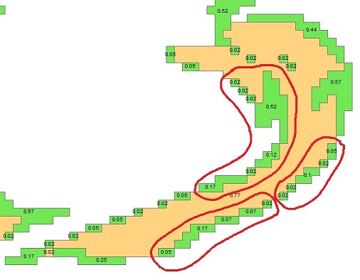
Raster to Polygon

3
  • 2
    It's unclear what the question is because neither the text nor the figure help us understand what constitutes a "polygon". Nevertheless, it sounds like you may be looking for Regiongroup with the "EIGHT" option for the neighbors.
    – whuber
    Commented Mar 14, 2012 at 22:25
  • Each green object in the image is a polygon that has been converted from a cell. For example, in the upper example, there are 7 polygons (from upper left) of size .02, .02, .02, .52, .12, .02, .17 acres. I am was hoping to achieve 1 larger polygon of size .89 acres (sum of the 7 parts). Each of the circled areas would be their own polygons of respective summ size acres. Commented Mar 14, 2012 at 22:57
  • 2
    RegionGroup does exactly that, Ryan.
    – whuber
    Commented Mar 15, 2012 at 16:07

4 Answers 4

7

I can think of a few approaches that might be worth a try depending on what your data are (they will result in small changes):

  1. Did you have 'generalise polygons' switched on when you converted from raster to poly?
  2. You could change the resolution of your raster and use a conservative setting on one of the tools like Boundary-Clean or Nibble before converting to polygons (by up-sampling the resolution, it makes zero effect on the original areas but reduces the size of the change in the final data - you may not feel this is a concern depending on your data)
  3. You could buffer by a tiny amount (just bigger than your cluster tolerance).

I'm sure there are some other approaches, but I'm running out of steam this evening. Hope these ideas help.

3

The polygons you are attempting to merge need to share more than one vertex. You cannot dissolve and explode because the polygons that only share one vertex will be separated as well. If you merge the circled groups manually they will become multigeometry as they are not actually intersecting. @Sylvester suggested generalizing when converting as well as other methods. You could try that. One crude method is to buffer all the polygon features by a small positive number then buffer again by the same small negative number which will join the polygons but it will round off inner corners. It will also introduce a lot of vertices which may not be desirable.

2
  • I understand that I needed more than 1 vertex to dissolve, thats why I am asking the question. I will give the "small buffer" concept a try. That just might work. Commented Mar 15, 2012 at 14:08
  • When RegionGroup is applied with the "EIGHT" option, sharing one vertex is enough for two cells to be considered part of the same polygon.
    – whuber
    Commented Mar 15, 2012 at 16:06
0

If I understand correctly you could just use the dissolve tool to essentially turn the separate green polys into one multipart polygon, then add a new area field and recalculated the acres.

Hope this helps Tyler

0

I had almost exactly the same dilemma. The following worked at least to approximate. I used the Polygon smooth tool to "round" the pixel squares, then the aggregate tool. After smoothing, the polygons touched on more than just a node, so the aggregate tool could work its magic.

1
  • After trying a couple of smoothing methods, they either add too much area or don't create enough edge to aggregate in some polygons. So, I went back and used the method suggested by Jakub above in 2012... much better! It would be great if Esri included the option in the aggregate tool to aggregate polygons that touch on a node (point).
    – Lisa
    Commented Sep 2, 2016 at 16:17

Your Answer

By clicking “Post Your Answer”, you agree to our terms of service and acknowledge you have read our privacy policy.

Not the answer you're looking for? Browse other questions tagged or ask your own question.