1

I want to transform about 750 addresses into geocoded points. I´ve tried the plugins MMQGIS (Geocode) and Geopunt4Qgis but none of the things I´ve tried worked. Maybe its because the addresses are German or the table is not formatted correctly before I export it to a CSV file.

the table looks like this:

Table

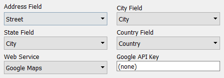
this is what I type in MMQGIS (the City is at the time a state, there is also no option for house numbers)

picture

this is the error I get:

enter image description here

this is in Geopunt4Qgis (there is an option for house numbers but I don´t have the postal code)

picture 2

Any solutions apart from QGIS are also welcome. Any ideas?

3
  • 2
    Google recently this year changed their geocoding services. There is no longer free geocoding available from Google. See this question for more info: gis.stackexchange.com/questions/294733/…
    – cbunn
    Commented Sep 13, 2018 at 18:57
  • there are not any other services? in MMQGIS for example you can also use OpenStreetMap
    – Lutz
    Commented Sep 14, 2018 at 10:23
  • You can use the Nomatim service in MMQGIS but it is not as robust as Google's geocoder. Take a look at this question and maybe it will help you figure out if the problem is coming from how you scraped the data: stackoverflow.com/questions/17912307/u-ufeff-in-python-string.
    – cbunn
    Commented Sep 17, 2018 at 13:33

0

Browse other questions tagged or ask your own question.