I recently came across this tutorial suggesting that the RQGIS and tigris R packages could be used to overcome issues with non-nested geographies:
https://rpubs.com/corey_sparks/256942
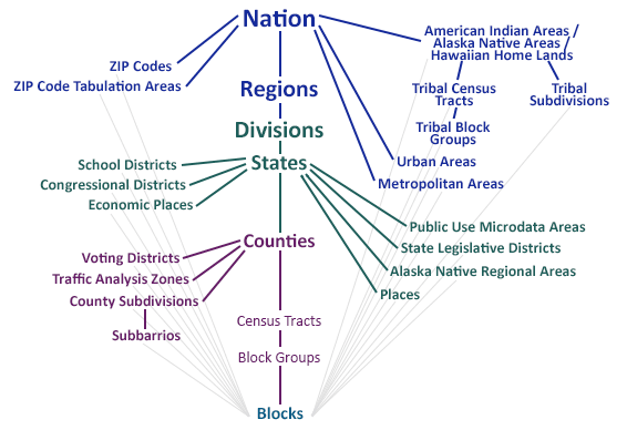
I'm trying to apply this to some data I have where I would like to look at Census Block Groups nested within Zip Code Tabulation Areas. Specifically, I'd like to compute a segregation index using Census Block Groups as the lower units and Zip Code Tabulation Areas as the higher level units. As shown in the figure below, these are definitely not nested geographical units:
I am confused about how these R packages deal with this issue of non-nested units. Here's the explanation from the tutorial:
"In order to get around this problem [non-nested units], we can use the QGIS application to perform a geographic intersection between two spatial polygon layers that we want to use. This will allow us to merge the population data at the census tract level to a higher level, so we can calculate a segregation index."
Can anyone say more about how this is possible? I can run the code in the tutorial but I don't understand what it's doing.

