2

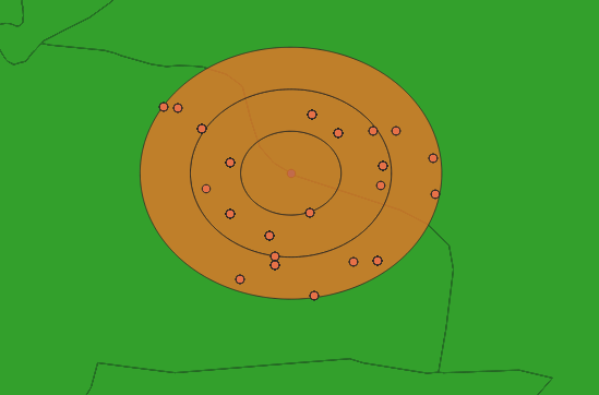
A boundary runs through the buffer shown. I am attempting to extract all points within the buffer on either side of the boundary, distinguishing which side of the boundary the points are on.

Is there an easy way to do this using QGIS?

I have 27 buffers in total and over 3000 points fall within these buffers so 'extracting by location' and then sorting visually is not feasible.

1
  • 2
    Vanessa - conceptually you take the buffer you already created, use an intersection tool to cut the buffer by the boundaries (leaving only a cut in half buffer), then spatially intersect the points to each side. Spatial SQL through PostGIS is my tool of choice, but QGIS has the processing tools to do this as well. Commented Aug 1, 2019 at 0:39

1 Answer 1

1

If that example is using AcrMap, you can use the Select by Lasso tool which would capture the desired points.

You could also select the boundary of interest set up a Definition Query. This will only display the boundary polygon of interest. From there, you can use the Select by Location to grab the points within the buffer.

If there are additional points within the boundary but outside of that buffer (extra undesired points are selected), you can go a step deeper with the Select by Location (when the points are selected). Change the Selection Method and the source to the buffer polygon layer so the only points to remain selected will fall within the buffer and the boundary.

3
  • I am using QGIS, do you know if it is possible on this program?
    – Vanessa
    Commented Aug 1, 2019 at 0:30
  • In QGIS the Select by Lasso tool is called Select Feature by Freehand. Commented Aug 1, 2019 at 0:59
  • Thank you James. Is there a way to select features from multiple layers at once and extract as one file?
    – Vanessa
    Commented Aug 1, 2019 at 2:05

Your Answer

By clicking “Post Your Answer”, you agree to our terms of service and acknowledge you have read our privacy policy.

Not the answer you're looking for? Browse other questions tagged or ask your own question.