1

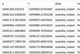
The issue I'm having is that when I go to export the XY co-ordinates of point data to a CSV file, I'm getting metres in the columns instead of the decimal degrees I was expecting. I've tried all variations of setting both in the project preferences and the export pane, but still getting the same result.

I've looked around this forum, I've tried all the solutions offered on other posts, but I still get metres in my export, instead of decimal degrees. It used to work without any change to the default settings. I may have check a box somewhere, but I can't see it.

This is what I get on export

csv output

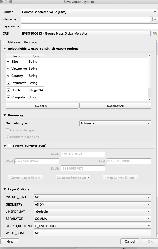
And here are the settings on the export:

Export settings

The co-ordinates are displaying as decimal degrees in the main viewer window:

enter image description here

I've spent way too long trying to fix this.

2
  • 3
    There's a Save as... CRS=Google...Mercator in your export panel. I certainly hope the resulting coordinates would be Web Mercator.
    – Vince
    Commented Mar 19, 2020 at 23:31
  • 7
    If you want decimal degrees in your output, change your output coordinate system from one that uses metres (i.e. the EPSG:900913 you selected), to one that uses decimal degrees (i.e WGS84 Geographic EPSG:4326).
    – user2856
    Commented Mar 20, 2020 at 1:25

1 Answer 1

2

There are many ways to achieve this. One of the methods is the following.

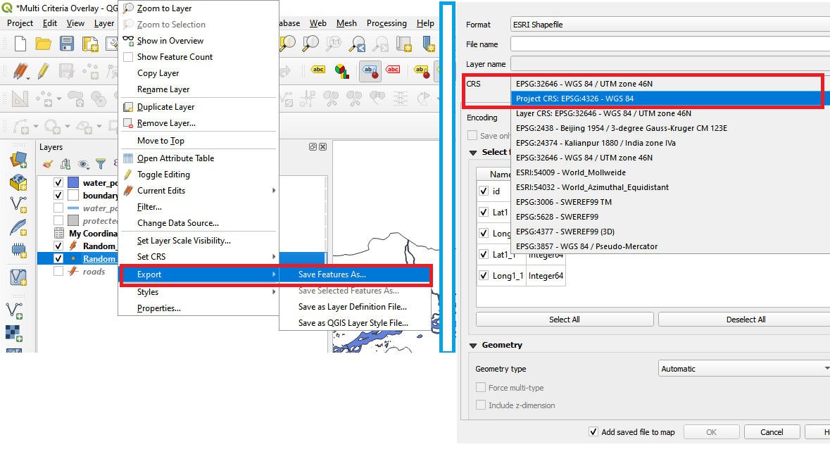
  1. Export the point shapefile into another shapefile. Make sure to change the CRS of the new file is WGS84 (EPSG4326).
  2. In the “Layers” panel, open the attribute table for this new layer you just created.

enter image description here

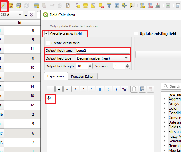
  1. Click on “Toggle Editing Mode”, and open “Field Calculator”.

  2. Make a new field type of real, name it as “Latitude”, and in the panel write $y. Click OK and this will create a new field (i.e., column) with the latitude of all the points.

enter image description here

  1. Similarly, make a new field with the name ‘Longitude’ using the expression $x in the field calculator.
  2. Save the edits and turn of Toggle Editing Mode.

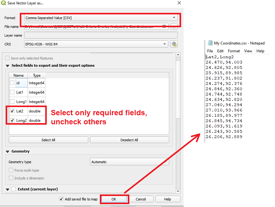
  3. Now in the layer panel, export the layer. Select CSV as the file type. Uncheck all other fields except your newly created “Latitude”, and “Longitude”.

enter image description here

  1. Your CSV file with coordinates in decimal degrees is ready. You can now convert them in Degrees Minutes Seconds using any spreadsheet program if you want.

Your Answer

By clicking “Post Your Answer”, you agree to our terms of service and acknowledge you have read our privacy policy.

Not the answer you're looking for? Browse other questions tagged or ask your own question.