3

I have a 6 band Landsat image, RGB and 3 NIF bands. As far as the Band Interleaved by Line (BIL) method goes, the resulting image should have, and I quote ENVI manual:

the first line of the first band followed by the first line of the second band, followed by the first line of the third band, interleaved up to the number of bands. Subsequent lines for each band are interleaved in similar fashion. This format provides a compromise in performance between spatial and spectral processing and is the recommended file format for most ENVI processing tasks.

So with 6 bands, I should get something like this: BIL logic simplified
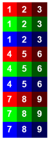
With the resulting image "streched" with the same row number from each of the band in sequential order, or 6 rowed blocks per the whole image.

However, the result ended up like this: BIL logic in reality and with 800*800 pixels, each segment is clearly more than just 6 rows.
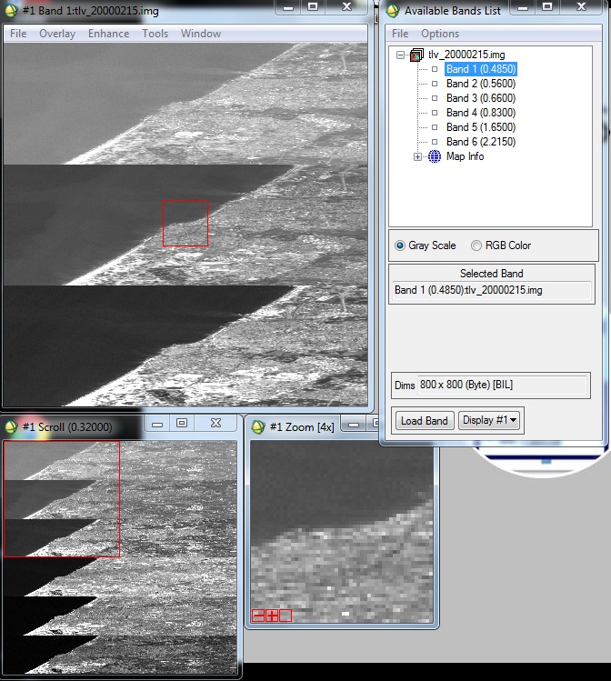
I am at lost as to why it's displayed this way.

Appreciate any help in regards to the matter.

3
  • Not having access to ENVI and not having used it in a while, this is interesting to me. I haven't had experience with the BIL format, but it seems like it's a way of storing multi-band data in one band (correct me if I'm wrong). Since this has 6-bands, is it really a BIL file? If there's a way to tell it that it's a standard 6-band img file, that might fix the display issues.
    – bluefoot
    Commented Oct 22, 2012 at 16:53
  • How do you come up with the pattern in the first illustration? I cannot find any interpretation in which it conforms to the BIL description, which would place line 1 for bands 1, 2, 3, 4, 5, 6 first (each succeeding one another), followed by line 2 for bands 1, 2, ..., 6, etc. To help us figure out what's going on, please tell us more than what the "result" is: what did you actually do? What does the Landsat metadata tell you about the format of the image file? What did you specify to your software in order to open that file?
    – whuber
    Commented Oct 22, 2012 at 17:46
  • @whuber the pattern in the 1st illustration is what a basic search on the internet got me, as well as the slideshow of the class this exercise is part of. The "result" is clearly shown in the available band list window, with all the bands, and the interleave type. to open that file, I uploaded the image file, that's it.
    – HDunn
    Commented Oct 25, 2012 at 6:17

2 Answers 2

1

You may have a BIP (Band Interleaved by Pixel) or BSQ (Band Sequential) format. The ESRI help has a reasonable page that illustrates the three interleave methods.

Right-click on the file in the "Available Bands List" window and select "Edit Header..." and switch the interleave from BIL to BIP (if that is what your data actually is, otherwise try BSQ) and it should display properly.

If you actually want to convert your image data to BIL, select "Basic Tools"->"Convert Data (BSQ,BIL,BIP) from the ENVI toolbar.

1
  • The whole idea of this exercise is to understand the differences BSQ, BIL and BIP. I have no need to convert the image data, just change the header interleave type, which got me the result I've shown in the OP.
    – HDunn
    Commented Oct 25, 2012 at 6:24
1

It appears that the source of the problem lies in the fact that I am only selecting one layer at a time, as you can see in the picture I added, only band 1 is selected.

As a result, the display takes the first line form the first band, and instead of adding the first band from the next 5 bands, it doesn't, then add the 7th line from band 1, then the 13th line, etc. and that results in a "squashed" image.

though this explanation sheds some light on the top-most sixth of the image, and with this logic it can do the same for the next 5 bands and the following 5 parts of the resulting image, it still doesn't explain why it does that, given I have selected only 1 band.

Your Answer

By clicking “Post Your Answer”, you agree to our terms of service and acknowledge you have read our privacy policy.

Not the answer you're looking for? Browse other questions tagged or ask your own question.