2

I often have two datasets that are obviously not georeferenced correctly. Most of the time a simple translation (shift by x/y) could fix this.

Is there an easy way to do this e.g. by specifying one or two reference points in the reference raster and the raster that is to be corrected?

Is there a simple WYSIWYG-approach (e.g. in ArcMap) to manually/visually reference one dataset with some points to another and perform the transformation?

This seems like such a basic and straightforward task, that I think a tool should exist for it, but I know of none amongst the several tools at my disposal (ArcGIS, QGIS, R, Python, GDAL, ...). I am aware of Shift Raster (Data Management) in ArcMap, but it requires known X/Y coordinates for the shift and doesn't work on vector-datasets. A workaround would be to extract coordinates of the two points, manually calculate the shift, and then use it with the tool. I'm hoping for something more elegant though. I also found Transform Features (Editing) in ArcMap, which is fine but this too is restricted (only feature datasets) and circumstantial (as far as I understand one has to create features to represent the transformation).

E.g. for the data below I know that the green dataset is positioned right. Therefore I'd like to perform the translation represented by the yellow arrow (x -> o) on the complete grey raster data (and actually two other datasets as well). I'd love to be able to do this by just clicking at those two points and then on "shift".

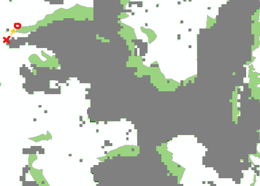
data that is not aligned perfectly, but could be with a simple shift

1

1 Answer 1

2

Depending on the data/problem, there are different approaches:

  1. Datum shift: Your case appears to be a datum shift because everything is constantly offset to bottom left. You may be able to fix that by setting the transformation on your map? That would be the easiest approach taking about 5 seconds...

  2. Coordinate shift: If the shift is because the data was collected/created in the wrong coordinate system then you have to do what you are doing, shift it.

    • Vector/Feature data: The spatial adjustment toolbar provides a WYSIWYG-approach. All the information you need is in the help file on these pages. However the Editor/Spatial Adjustment bars only work with vector data.

    • Raster data: As suggested in the comments, the corresponding WYSIWYG approach for raster data is the georeferencing toolbar.

2
  • 1
    Raster version would be to re-georeference the offset raster.
    – mkennedy
    Commented Dec 14, 2020 at 18:29
  • thank you Hornbydd and @mkennedy as well. As I was working with raster data, the georeferencing toolbar was what I was looking for. super easy then :) I incorporated it into the answer and edited it to reflect all three scenarios (datum shift, coordinate shift with vector/raster data) - I hope the edits will be accepted
    – Honeybear
    Commented Feb 2, 2021 at 11:30

Your Answer

By clicking “Post Your Answer”, you agree to our terms of service and acknowledge you have read our privacy policy.

Not the answer you're looking for? Browse other questions tagged or ask your own question.