1

I am currently working the QGIS software and I want to extract roads of a certain region from OSM (Open Street Maps) in order to create a black and white .tiff mask as follows: The roads that should be exported to .tiff
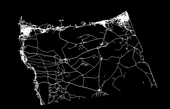
It is also preferable that the mask keeps the geoData encapsulated.

I do have 2 layers, the vector roads and the black background that is behind them. My problem is with exporting, as the background is big (33806 * 21462 px) I was not able to export the above picture with this exact desired size (which is crucial for my project).

I do however have the vector roads in a .dxf file and a black background as .tif with the desired height and width, each one by itself.

I am looking for a way to merge them into one file without losing the original size. I tried using ArcGIS but I am not familiar with it.

3
  • 1
    Please explain, how you're going about the export and why it doesn't work out for you.
    – Erik
    Commented Apr 3, 2021 at 15:55
  • If we are talking about QGIS, I planned to export using the "Export to image" submenu, and then selecting the black map as a delimiter for coordinates, and putting the scale to 1:1. When I do this the size of the image to export becomes > 99999 px * 99999 ( while my raster layer is exactly (33806 * 21462 px) as stated. Even if I input this exact size in the submenu, qgis still fails to export it. This is why I am looking to alternative solutions.
    – hattoum
    Commented Apr 3, 2021 at 21:12
  • A scale of 1:1 means that 1 m in the image corresponds to 1 m in reality. So if you have a pixel size of 10x10 m, one pixel of the image is exported as 10 x 10 pixel.
    – Erik
    Commented Apr 3, 2021 at 21:40

0

Your Answer

By clicking “Post Your Answer”, you agree to our terms of service and acknowledge you have read our privacy policy.

Browse other questions tagged or ask your own question.