2

Using ArcMap or ArcGIS 10 ...

In the photo below, you can see my extent is in meters while my projected coordinate system is in decimal degrees. How can I convert my layer extent to decimal degrees?
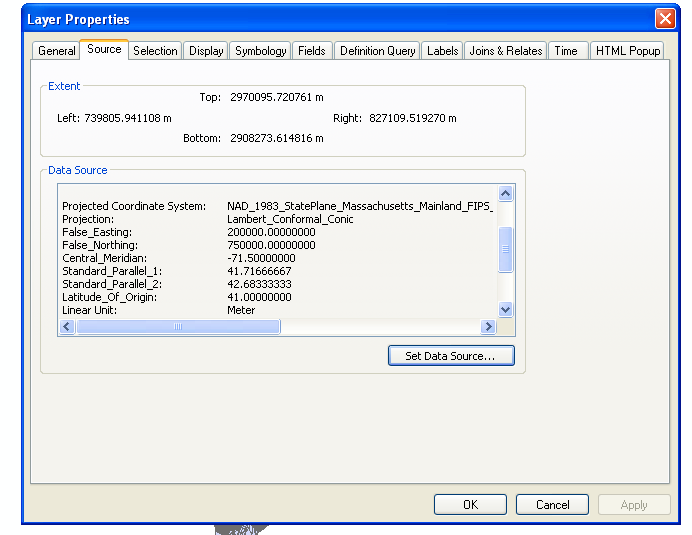
Extent is in meters, while projected coordinate system is in decimal degrees

8
  • 1
    Have you tried changing the coordinate system of your data frame? Right click in the map (not TOC) and go to Data Frame Properties.
    – Paul
    Commented Jun 10, 2014 at 15:59
  • 3
    You likely have to reproject your data to decimal degrees. Changing the display units or the data frame coordinate system won't change the extent of the layer, that is reporting the extent of the data in its native coordinate system ... what are you trying to do here? Commented Jun 10, 2014 at 16:10
  • 1
    By what do you mean "my projected coordinate system is in decimal degrees"? I see projection parameters in appropriate units, and projected coordinates in correct units.
    – Vince
    Commented Jun 10, 2014 at 16:11
  • Thanks @mapBaker I have code that reads shapefiles, though it requires lat long coordinates for each vertex of each shapefile. I believe by changing my layer extent to decimal degrees, this should manage that information in the metadata. Alternatively, is there a tool that gives the coordinates for each vertex of each shapefile?
    – Alex
    Commented Jun 10, 2014 at 16:17
  • 2
    Note: The layer extent in ArcMap always reports the extent in the data's native coordinate system, not the data frame's.
    – mkennedy
    Commented Jun 10, 2014 at 18:35

2 Answers 2

2

It looks like you are maybe misunderstanding what ArcGIS is telling you here. Your coordinate system is not in decimal degrees, it's in meters. The "Central Meridian", "Standard Parallel 1", and other values you are seeing in the Data Source box are simply describing the coordinate system your data is using, they do not represent the actual coordinates of your data.

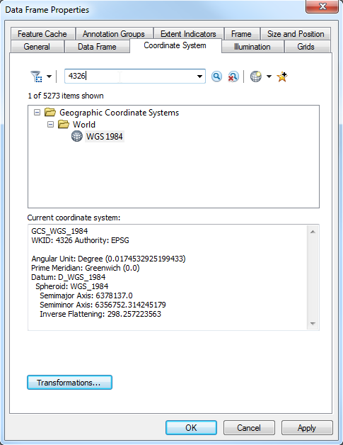
If you have code that requires the shapefile to be in Lat/Long, you would need to reproject this shapefile to that coordinate system. One way to do that in ArcGIS is to set the Data Frame Properties to use the coordinate system you want as Alex said (lat/long WGS84), then right-click the shapefile in ArcMap, click Data, Export Data, select "Use the same coordinate system as the data frame", and give the output a name:
enter image description here

3
  • Sorry @ Dan - I missed the last line below the screenshot with the export explanation. Thanks to those who pointed out my oversight. Deleted my answer.
    – JWallace
    Commented Jun 10, 2014 at 19:23
  • 1
    I think your answer was fine, there's more than one way to reproject a shapefile and yours works too.
    – Dan C
    Commented Jun 10, 2014 at 19:24
  • 1
    @JWallace When doing something basic in ArcGIS, there's often more than one way to achieve the goal. By deleting your answer you also removed Melita's recommendation to deproject into NAD83 vice doing NADCON to WGS84.
    – Vince
    Commented Jun 10, 2014 at 20:26
1

An alternative to @Dan's method of exporting from the data frame properties is to use the Project tool in ArcToolbox. To reproject your shapefile, access ArcCatalog, select Data Management Tools - Projections & Transformations - Feature - Project. Select WGS 1984 as your output coordinate system and specify a new file name. This projected shapefile should meet the Lat/Long input criteria for your code.

2
  • There are actually multiple ways to reproject data, with the Project tool and "export in the CS of the data frame" being the two easiest, so Dan's complete methodology is equally valid (they even use the same exact code under the hood).
    – Vince
    Commented Jun 10, 2014 at 18:35
  • 1
    Did you miss the end of @dan-c answer? An alternative method to create a new feature class in a different coordinate system is to export from ArcMap. I would also suggest that the data's GCS, NAD 1983, be used rather than WGS 1984.
    – mkennedy
    Commented Jun 10, 2014 at 18:37

Your Answer

By clicking “Post Your Answer”, you agree to our terms of service and acknowledge you have read our privacy policy.

Not the answer you're looking for? Browse other questions tagged or ask your own question.