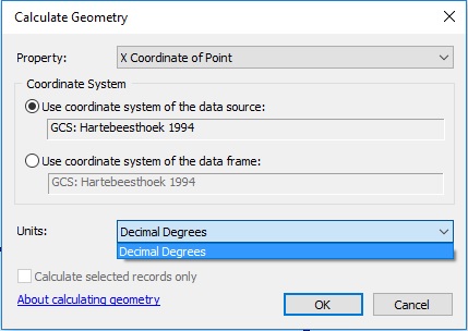
ArcGIS is sensibly not allowing you to do this, because if it did, you would get coordinates that represented the distance in meters from 0° longitude 0° latitude along an angular pathway.
Coordinates represent location with respect to a specific coordinate reference system (CRS). You have coordinates measured in decimal degrees in an angular (geographic) coordinate system, and are asking for a result which only makes sense in a planar (projected) coordinate system. By using the Calculate Geometry tool and looking for the option to output the result in meters, you are asking to have those coordinates converted from decimal degrees to meters without changing the coordinate system. If ArcGIS allowed you to do that and you attempted to use those numbers to calculate distances or areas, the results would be nonsense, or worse than nonsense because they would look like real measurements, but be wrong.
I assume you want your coordinates in meters because you want to display a sensible scale bar or calculate distances or areas in meters. If that is the case, then what you actually want to do is project your coordinates to a suitable planar coordinate system. You can do this using the Project tool in ArcToolbox, or using a variety of standalone tools (such as ogr2ogr) or other GIS software. What constitutes a suitable projection really depends upon your purposes, region of the globe, and extent of coverage.

