1

Admin boundaries are available in https://www.humanitarianresponse.info/en/operations/federated-states-micronesia/dataset/micronesia-federated-states-admin-level-1-boundaries as a file geodatabase (*.gdb) but I currently don't have Esri software to read them.

How can I convert it to KML or SHP format?


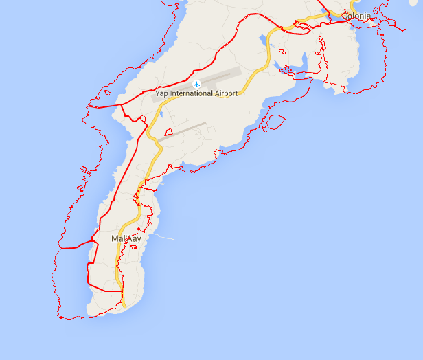
I get the following...what projection should I use to fix this?enter image description here it is currently 4326

3
  • 5
    You can open them in QGIS which is a free GIS software and do the conversion yourself.
    – Hornbydd
    Commented Jun 24, 2015 at 12:16
  • 1
    For help with emergency responses we have a Meta Q&A concerning ideas for how to enlist our community's assistance.
    – PolyGeo
    Commented Jun 24, 2015 at 12:24
  • 2
    I think your new question should be researched/asked separately from the original.
    – PolyGeo
    Commented Jun 25, 2015 at 10:25

3 Answers 3

5

You can also use GDAL/OGR directly (which is what QGIS uses behind the scenes). It requires a special driver, but if you get it via OSGEO4W, that is included. Command line would look something like:

ogr2ogr -f kml -select desired,attribute,fields outfile.kml infilegeo.gdb filegeolayername

There are some kml-specific options too, see http://www.gdal.org/drv_kml.html

1

FME by Safe Software also does this, rather easily -- you could use the trial if it's a short-term solution you're looking for. You would read from ESRI fgdb and write into KML, and can add whatever you need in-between (re-projection, KML stylings, etc).

An unnecessarily lengthy FME tutorial for working with KML conversions: http://cdn.safe.com/training/tutorials/KML-Pathway-Tutorial.pdf

0

In answer to the original request

Just in case you can't access QGIS, I've created three separate shapefiles and put them on dropbox. The projection of these shapefiles is EPSG:4326

https://dl.dropboxusercontent.com/u/71658964/miconesia.zip

Another dataset you may also be interested in is the WMS service GSJ CCOP Combined Bedrock and Superficial Geology and Age

To assist with the follow-up question/issues

I used ogrinfo on the original file and it tells me the projection is EPSG:4326, I think, for example:

ogrinfo -so FSM_adm_SBOC_PCRAFI.gdb state

Had to open data source read-only.
INFO: Open of `FSM_adm_SBOC_PCRAFI.gdb'
      using driver `OpenFileGDB' successful.

Layer name: State
Geometry: Multi Polygon
Feature Count: 4
Extent: (137.491872, 1.022685) - (163.051392, 10.036174)
Layer SRS WKT:
GEOGCS["GCS_WGS_1984",
    DATUM["WGS_1984",
        SPHEROID["WGS_84",6378137.0,298.257223563]],
    PRIMEM["Greenwich",0.0],
    UNIT["Degree",0.0174532925199433]]
FID Column = OBJECTID
Geometry Column = Shape
SID: Real (0.0)
State: String (0.0)
Census_00: Real (0.0)
Proj_10: Real (0.0)
Shape_Length: Real (0.0)
Shape_Area: Real (0.0)

Looking at your backdrop, I can see it has come from Google Maps. So you will probably want to convert the shapefiles to EPSG:3857 - WGS84 / Pseudo Mercator, or just save the file geodatabase to a shapefile in that CRS.

It is possible though that the original data is not in EPSG:4326 (WGS 84), it might be worth looking at projections using earlier geodetic systems.

The YAP STATE CODE tells us for instance:

The Yap Islands coordinate system is hereby defined as a modified azimuthal equal distance projection in which the geodetic origin and the geodetic distance and the grid azimuth coincide at the point of origin and the geodetic distance and the grid distance are the same between the point of origin and any other point of the projection. This projection is based on the Clark Spheroid of 1866 and the 1965 Guam Datum. The point or origin of the system is station "YAP SECOR AMS 1965", having assigned to it the coordinates NORTH 60,000.00 meters, and EAST 40,000.00 meters. The geodetic position of "YAP SECOR" is 9 degrees 32 minutes 48.15 seconds NORTH latitude and 138 degrees 10 minutes 7.48 seconds EAST longitude. The basis of this coordinate system shall be the survey network established by the Army Map Service 1965 and extended by the U.S. Geological Survey in 1970.
4
  • Thanks everyone. I do have qgis but thought you needed arcgis licence to open fgdb files. @PolyGeo thanks for the link to Meta Q&A.
    – GeorgeC
    Commented Jun 24, 2015 at 13:26
  • I get a projection issue, any ideas? see edited question please.
    – GeorgeC
    Commented Jun 24, 2015 at 13:55
  • Thanks, NMTOKEN but I still have the same issue. I tried to re-project it in QGIS but it ends up the same. See google.com/maps/d/u/0/edit?mid=zP3SEATdJHlg.kxO1tFajWNoo
    – GeorgeC
    Commented Jun 25, 2015 at 9:12
  • Assuming GM and GE aren't incorrect (it's possible) you could try to corroborate with some other data source, for example location of runways on Yap, you must assume that the original data has an incorrect projection proscribed. There is a contact for the data on the humanitarian response site, and as an attempt to resolve this you should contact them in the first instance, I think.
    – nmtoken
    Commented Jun 25, 2015 at 11:42

Your Answer

By clicking “Post Your Answer”, you agree to our terms of service and acknowledge you have read our privacy policy.

Not the answer you're looking for? Browse other questions tagged or ask your own question.