0

I have been counting muskrat dens on lakes with aerial photos by creating a feature in a separate shapefile. I checked my progress after doing about 80 small lakes and suddenly, half of the lakes were off of their correct location (7.5 km south) and half of them are in the right spot.

I can't seem to remember, but I think that I wanted to confirm that the projection was correct and I confirmed the right projection of the layer.

Is it possible that this confirmation changed the first half of my layers and when I continued with the rest, they were placed correctly?

Is there anyway to reproject some of the features in a shapefile?

0

1 Answer 1

3

It does sounds like you have changed the CRS half through adding the features.

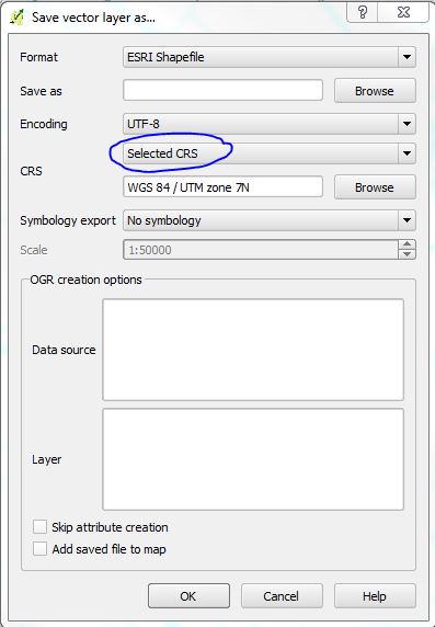
You can re-project those points by selecting them, then right click on the shapefile layer in the table of contents and select 'Save selection as'.

You can then choose to re-project those features to 'Selected CRS' and choose the appropriate CRS from the list.

enter image description here

Finally you will want to merge your exported Shapefile (now with correct CRS) with the original Shapefile (you will also need to delete the incorrect features before merging). This can be done using the 'Merge Shapefiles to one' tool found in the 'Vector' > 'Data management tools' menu.

10
  • Okay, this works perfectly up until you merge them. I realized that the mistake I made was: Intended CRS : UTM zone 7N Aerial photos, lake perimeters use this CRS The default projection was WGS 84 and when I created the shapefile, I forgot to change it to zone 7N. Doesn't that mean the half that are in the different projection won't be able to be combined?
    – Alec
    Commented Feb 18, 2014 at 14:36
  • When I have two layers, one with non-problem features and the other problem features reprojected in their original, incorrect CRS, all features are in their correct spot.
    – Alec
    Commented Feb 18, 2014 at 14:41
  • 1
    If you have two Shapefiles, both with the same CRS and both showing features in the correct position then you should have no problem when you merge them.
    – Matt
    Commented Feb 18, 2014 at 14:43
  • But its because the one shapefile was created and features with coordinates were created, using the wrong projection..
    – Alec
    Commented Feb 18, 2014 at 14:44
  • When you export the Shapefile you can select a different target CRS.
    – Matt
    Commented Feb 18, 2014 at 14:46

Your Answer

By clicking “Post Your Answer”, you agree to our terms of service and acknowledge you have read our privacy policy.

Not the answer you're looking for? Browse other questions tagged or ask your own question.